IMAGES TAKEN NEAR TO
Great Strickland, PENRITH, CA10 3DH
Introduction
This page details the photographs taken nearby to CA10 3DH by members of the Geograph project.
The Geograph project started in 2005 with the aim of publishing, organising and preserving representative images for every square kilometre of Great Britain, Ireland and the Isle of Man.

There are currently over 7.5m images from over14,400 individuals and you can help contribute to the project by visiting https://www.geograph.org.uk
Image Map
Images are licensed for reuse under creativecommons.org/licenses/by-sa/2.0
Notes
- Clicking on the map will re-center to the selected point.
- The higher the marker number, the further away the image location is from the centre of the postcode.
Image Listing (5 Images Found)
Images are licensed for reuse under creativecommons.org/licenses/by-sa/2.0
Image
Details
Distance
1
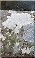
Ordnance Survey Rivet
Only the arrow remains of this OS rivet. It can be found on the south parapet of the bridge. It marked a point 181.874m above mean sea level.
Image: © Adrian Dust
Taken: 22 Mar 2018
0.03 miles
2
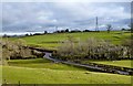
Road To Great Strickland
Strickland Mill is hidden in the trees beside the road bridge
Image: © David Liddle
Taken: 7 Feb 2013
0.05 miles
3
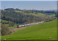
Pendolino at Great Strickland - April 2017
A Virgin Trains "Pendolino" set sweeps past Great Strickland as it heads north with the 11.43 passenger service from Euston to Glasgow Central.
Image: © The Carlisle Kid
Taken: 8 Apr 2017
0.16 miles
4
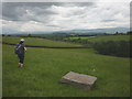
Footpath above the Leith
Down through pastureland to the lane leading to Great Strickland. Cross Fell and the North Pennines beyond.
Image: © Karl and Ali
Taken: 6 Jul 2014
0.20 miles
5
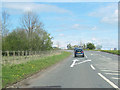
Junction for Great Strickland from A6 north
The A6 bears left here and crosses the M6.
Image: © John Firth
Taken: 9 May 2012
0.24 miles