IMAGES TAKEN NEAR TO
Church View, PENRITH, CA10 3AB
Introduction
This page details the photographs taken nearby to Church View, CA10 3AB by members of the Geograph project.
The Geograph project started in 2005 with the aim of publishing, organising and preserving representative images for every square kilometre of Great Britain, Ireland and the Isle of Man.

There are currently over 7.5m images from over14,400 individuals and you can help contribute to the project by visiting https://www.geograph.org.uk
Image Map
Images are licensed for reuse under creativecommons.org/licenses/by-sa/2.0
Notes
- Clicking on the map will re-center to the selected point.
- The higher the marker number, the further away the image location is from the centre of the postcode.
Image Listing (26 Images Found)
Images are licensed for reuse under creativecommons.org/licenses/by-sa/2.0
Image
Details
Distance
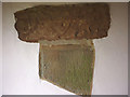
1
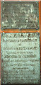
Inscribed Roman pillar, porch of St Cuthbert's Church, Cliburn
According to information in the church this and other inscribed stones originally came from the Roman fort at Kirkby Thore (Bravoniacum http://www.roman-britain.org/places/bravoniacum.htm ) This link http://romaninscriptionsofbritain.org/inscriptions/791 , however suggests Brougham as a more likely origin
Image: © Karl and Ali
Taken: 25 May 2015
0.06 miles
2
Inscribed Roman stones, porch of St Cuthbert's Church, Cliburn
Two more incorporated Roman stones http://romaninscriptionsofbritain.org/inscriptions/791#translation
Image: © Karl and Ali
Taken: 25 May 2015
0.06 miles
4
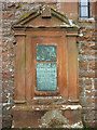
Monument, St Cuthbert's Church, Cliburn
A carved sandstone monument with inscribed metal plaques to commemorate the Reverend Robert Stephenson and his wife, Bridget.
'Life how short, Eternity how long'- Bridget died in 1773, aged only 40. Robert was rector of Cliburn for over 40 years and died in 1802 aged 79.
Image: © Karl and Ali
Taken: 25 May 2015
0.06 miles
5
Plaques on monument, St Cuthbert's Church, Cliburn
Two inscribed metal plaques on Image
Image: © Karl and Ali
Taken: 25 May 2015
0.06 miles
6
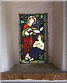
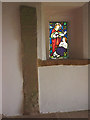
Window
Window in the porch of St Cuthbert's Church - Cliburn.
Image: © mauldy
Taken: 17 Aug 2006
0.07 miles
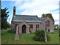
7
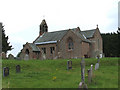
St Cuthbert's Church
St Cuthbert's Church - Cliburn.
Image: © mauldy
Taken: 17 Aug 2006
0.07 miles
8
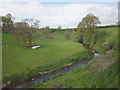
The River Leith above Cliburn
A lovely pastoral valley as seen from the graveyard of St Cuthbert's Church.
Image: © Karl and Ali
Taken: 25 May 2015
0.09 miles
9
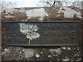
Parish boundary marker, Cliburn Town Bridge
An iron plaque marking the parish boundary between Cliburn and Morland parishes with the year 1847.
Image: © Karl and Ali
Taken: 25 May 2015
0.11 miles
10
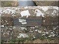
Old Boundary Marker on Cliburn Town Bridge
Parish Boundary Marker by the UC road, in parish of Cliburn (Eden District), Cliburn Town Bridge, centre of bridge parapet, East side of road.
Inscription reads:-
: PARISH OF / CLIBURN / 1847 : : PARISH OF / MORLAND / 1847 :
Surveyed
Milestone Society National ID: WE_CLIMOR01pb
Image: © Milestone Society
Taken: Unknown
0.11 miles