IMAGES TAKEN NEAR TO
Bampton, PENRITH, CA10 2RP
Introduction
This page details the photographs taken nearby to CA10 2RP by members of the Geograph project.
The Geograph project started in 2005 with the aim of publishing, organising and preserving representative images for every square kilometre of Great Britain, Ireland and the Isle of Man.

There are currently over 7.5m images from over14,400 individuals and you can help contribute to the project by visiting https://www.geograph.org.uk
Image Map
Images are licensed for reuse under creativecommons.org/licenses/by-sa/2.0
Notes
- Clicking on the map will re-center to the selected point.
- The higher the marker number, the further away the image location is from the centre of the postcode.
Image Listing (6 Images Found)
Images are licensed for reuse under creativecommons.org/licenses/by-sa/2.0
Image
Details
Distance
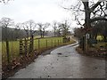
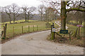
2
Bridleway north west of Naddle Farm
Rising through woods towards the dam at Haweswater.
Image: © Karl and Ali
Taken: 10 Apr 2010
0.05 miles
3
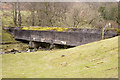
Culvert over the Naddle Beck
This carries water from the reservoir in Wet Sleddale into Haweswater
Image: © Tom Richardson
Taken: 8 Mar 2011
0.06 miles
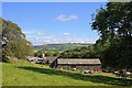
5
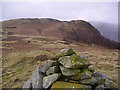
Naddle Low Forest
From the Outlying Wainwright 'nameless summit 1320 feet'. Looking towards Hugh's Laithes Pike
Image: © Michael Graham
Taken: 9 Mar 2008
0.24 miles