IMAGES TAKEN NEAR TO
Naddle Gate, PENRITH, CA10 2RL
Introduction
This page details the photographs taken nearby to Naddle Gate, CA10 2RL by members of the Geograph project.
The Geograph project started in 2005 with the aim of publishing, organising and preserving representative images for every square kilometre of Great Britain, Ireland and the Isle of Man.

There are currently over 7.5m images from over14,400 individuals and you can help contribute to the project by visiting https://www.geograph.org.uk
Image Map
Images are licensed for reuse under creativecommons.org/licenses/by-sa/2.0
Notes
- Clicking on the map will re-center to the selected point.
- The higher the marker number, the further away the image location is from the centre of the postcode.
Image Listing (42 Images Found)
Images are licensed for reuse under creativecommons.org/licenses/by-sa/2.0
Image
Details
Distance
2
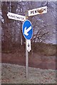
Direction Sign - Signpost at Burnbanks, Bampton parish
No finial - 2 arms; by the UC road, on grass triangle at Burnbanks, in parish of Bampton (Eden District).
Surveyed
Milestone Society National ID: WE_NY5116
Image: © Milestone Society
Taken: Unknown
0.04 miles
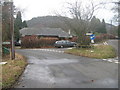
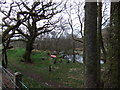
4
The Haweswater road south of Naddle Gate
Image: © Nigel Brown
Taken: 19 Sep 2013
0.11 miles
6
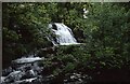
Thornthwaite Force
Thornthwaite Force on Haweswater Beck.
Image: © Philip Halling
Taken: 7 Jun 1991
0.11 miles
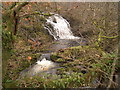
8
Gill Dubs
From the new Naddle Bridge looking upstream.
Image: © Russel Wills
Taken: 8 Jul 2014
0.13 miles
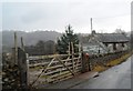
9
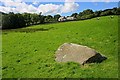
Boulder in a Field Near Thornthwaite Hall
Image: © Mick Garratt
Taken: 22 Aug 2010
0.13 miles
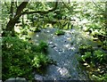
10
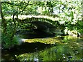
Naddle Old Bridge
Over Gill Dubs.
Original road bridge, to the east of the present road bridge. Built in the 1860s of stone rubble with long thin voussoirs. Segmental arch and abutments. No parapets. Roadway approximately 3.5 m wide.
http://www.geog.port.ac.uk/webmap/thelakes/html/lgaz/lk20580.htm
Image: © Russel Wills
Taken: 8 Jul 2014
0.14 miles