IMAGES TAKEN NEAR TO
Butterwick, PENRITH, CA10 2QQ
Introduction
This page details the photographs taken nearby to CA10 2QQ by members of the Geograph project.
The Geograph project started in 2005 with the aim of publishing, organising and preserving representative images for every square kilometre of Great Britain, Ireland and the Isle of Man.

There are currently over 7.5m images from over14,400 individuals and you can help contribute to the project by visiting https://www.geograph.org.uk
Image Map
Images are licensed for reuse under creativecommons.org/licenses/by-sa/2.0
Notes
- Clicking on the map will re-center to the selected point.
- The higher the marker number, the further away the image location is from the centre of the postcode.
Image Listing (9 Images Found)
Images are licensed for reuse under creativecommons.org/licenses/by-sa/2.0
Image
Details
Distance
2
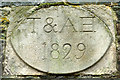
Date stone on barn, Butterwick
The stone is set into the barn visible here Image on the side facing Butterwick. It seems to read:
'T & AB 1829' but the final letter is not clear and could also be H?
Image: © Karl and Ali
Taken: 9 Feb 2013
0.07 miles
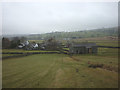
3
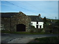
Fell End Farm, Butterwick, Penrith
Image: © Alexander P Kapp
Taken: 25 May 2006
0.08 miles
4
The footpath above Butterwick
The path to Gillhead climbs through pastureland above the hamlet in the Lowther Valley.
Image: © Karl and Ali
Taken: 9 Feb 2013
0.10 miles
5
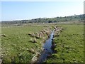
Ditch at Butterwick
In the level floor of the Lowther valley.
Image: © Oliver Dixon
Taken: 12 Apr 2019
0.11 miles
7
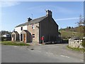
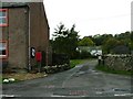
Scar View cottages
The Scar in question being Knipe Scar Image With post box.
Image: © Oliver Dixon
Taken: 12 Apr 2019
0.14 miles
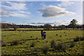
8
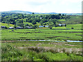
Green Crook
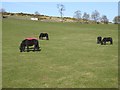
Broad meadow adjoining the River Lowther. The hamlet of Butterwick Image lies beyond. Loadpot Hill Image on the horizon.
Image: © Oliver Dixon
Taken: 11 Jun 2014
0.15 miles