IMAGES TAKEN NEAR TO
Askham, PENRITH, CA10 2QL
Introduction
This page details the photographs taken nearby to CA10 2QL by members of the Geograph project.
The Geograph project started in 2005 with the aim of publishing, organising and preserving representative images for every square kilometre of Great Britain, Ireland and the Isle of Man.

There are currently over 7.5m images from over14,400 individuals and you can help contribute to the project by visiting https://www.geograph.org.uk
Image Map
Images are licensed for reuse under creativecommons.org/licenses/by-sa/2.0
Notes
- Clicking on the map will re-center to the selected point.
- The higher the marker number, the further away the image location is from the centre of the postcode.
Image Listing (8 Images Found)
Images are licensed for reuse under creativecommons.org/licenses/by-sa/2.0
Image
Details
Distance
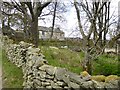
2
Sheep pens at High Rough Hill
Good quality infrastructure.
Image: © Jonathan Billinger
Taken: 14 Aug 2013
0.03 miles
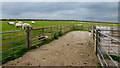
3
Gated road at Rough Hill
This is the second of four gates from south to north.
Image: © Jonathan Billinger
Taken: 14 Aug 2013
0.08 miles
4
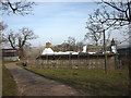
Restoration work at Low Rough Hill
A farm building or cottage is clad in scaffolding and being re-roofed.
Image: © Karl and Ali
Taken: 22 Mar 2015
0.11 miles
5
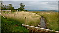
Gill Beck
Some recent work has taken place to presumably prevent flooding.
Image: © Jonathan Billinger
Taken: 14 Aug 2013
0.18 miles
6
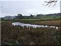
Rough Hill Tarn
A very small named tarn
Image: © David Brown
Taken: 26 Jan 2010
0.21 miles
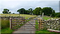
7
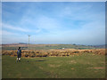
Rough pasture on Rough Hill
Looking north over Heltondale towards Heughscar Hill, a limestone outlier on the eastern fringes of the Lake District.
Image: © Karl and Ali
Taken: 22 Mar 2015
0.22 miles
8
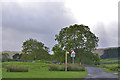
Road heading south from Cockle Hill
Leaving the open moor to pass through enclosed fields.
Image: © Nigel Brown
Taken: 29 Sep 2016
0.24 miles