IMAGES TAKEN NEAR TO
High Street, PENRITH, CA10 2NH
Introduction
This page details the photographs taken nearby to High Street, CA10 2NH by members of the Geograph project.
The Geograph project started in 2005 with the aim of publishing, organising and preserving representative images for every square kilometre of Great Britain, Ireland and the Isle of Man.

There are currently over 7.5m images from over14,400 individuals and you can help contribute to the project by visiting https://www.geograph.org.uk
Image Map
Images are licensed for reuse under creativecommons.org/licenses/by-sa/2.0
Notes
- Clicking on the map will re-center to the selected point.
- The higher the marker number, the further away the image location is from the centre of the postcode.
Image Listing (217 Images Found)
Images are licensed for reuse under creativecommons.org/licenses/by-sa/2.0
Image
Details
Distance
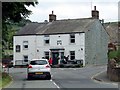
1
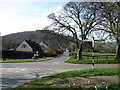
Pooley Bridge from the south-east
The road on the left, signposted Howtown and Martindale, runs along the south side of Ullswater. It is a (long) cul-de-sac. It is also narrow, twisty and very slow, so any driver not noticing this might waste quite some time before eventually returning to this junction!
The wooded hill behind the village is Dunmallard Hill.
Image: © David Purchase
Taken: 29 Mar 2012
0.01 miles
2
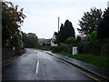
Pooley Bridge - the High Street (from the B5320)
The road to the hills and How Town
Image: © Tony Peacock
Taken: 2 Dec 2008
0.03 miles
3
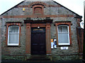
Pooley Bridge Public Hall in the High Street
Often open for local displays
Image: © Tony Peacock
Taken: 10 Oct 2008
0.03 miles
4
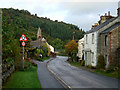
Pooley Bridge - The High Street looking to St Paul's Church
Into Pooley Bridge
Image: © Tony Peacock
Taken: 2 Dec 2008
0.04 miles
6
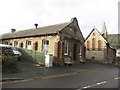
Parkin Memorial Hall, Pooley Bridge
The local community hall in Pooley Bridge.
Image: © Graham Robson
Taken: 31 Oct 2014
0.05 miles
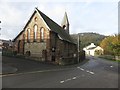
7
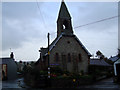
Pooley Bridge - St Paul's Church
At the start of the High Street.
Image: © Tony Peacock
Taken: 10 Oct 2008
0.05 miles
8
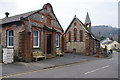
Parkin Memorial Hall and St Paul's church
Image: © Ian Taylor
Taken: 29 Mar 2014
0.06 miles
9
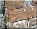
OS Bench Mark
OS cut bench mark from the 19th century levelling, on St Paul's Church. 495.5 feet above old datum. Weathered soft sandstone.
Image: © Phil Johnstone
Taken: 29 Nov 2021
0.06 miles
10
St Paul's Church, Pooley Bridge
The rear of St Paul's Church in Pooley Bridge.
Image: © Graham Robson
Taken: 31 Oct 2014
0.06 miles