IMAGES TAKEN NEAR TO
Pooley Bridge, PENRITH, CA10 2NG
Introduction
This page details the photographs taken nearby to CA10 2NG by members of the Geograph project.
The Geograph project started in 2005 with the aim of publishing, organising and preserving representative images for every square kilometre of Great Britain, Ireland and the Isle of Man.

There are currently over 7.5m images from over14,400 individuals and you can help contribute to the project by visiting https://www.geograph.org.uk
Image Map
Images are licensed for reuse under creativecommons.org/licenses/by-sa/2.0
Notes
- Clicking on the map will re-center to the selected point.
- The higher the marker number, the further away the image location is from the centre of the postcode.
Image Listing (9 Images Found)
Images are licensed for reuse under creativecommons.org/licenses/by-sa/2.0
Image
Details
Distance
2
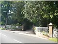
Entrance to Barton Hall
A 'country house B&B' on the north side of the B5320.
Image: © Christine Johnstone
Taken: 19 Sep 2015
0.09 miles
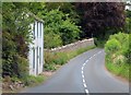
3
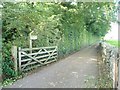
Public footpath to Mill Moor
Also the driveway to Barton Hall Farm.
Image: © Christine Johnstone
Taken: 19 Sep 2015
0.11 miles
4
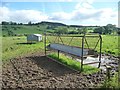
Well-used animal feeder, near Barton Hall
On the south-east side of the B5320.
Image: © Christine Johnstone
Taken: 19 Sep 2015
0.11 miles
5
Protected trees along the track to Barton Hall Farm
Looking north-west from the B5320.
Image: © Christine Johnstone
Taken: 19 Sep 2015
0.12 miles
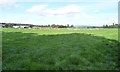
6
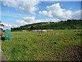
Fenced enclosures on farmland near Barton Hall
Purpose unknown.
Image: © Christine Johnstone
Taken: 19 Sep 2015
0.13 miles
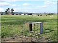
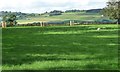
7
Sheep pasture south of Barton Hall Farm
Shaded by the trees in front of Barton Hall.
Image: © Christine Johnstone
Taken: 19 Sep 2015
0.14 miles
8
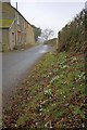
Bowerbank
First snowdrops of the year.
Image: © Mick Garratt
Taken: 14 Feb 2010
0.18 miles