IMAGES TAKEN NEAR TO
Margate Cross, PENRITH, CA10 2LN
Introduction
This page details the photographs taken nearby to Margate Cross, CA10 2LN by members of the Geograph project.
The Geograph project started in 2005 with the aim of publishing, organising and preserving representative images for every square kilometre of Great Britain, Ireland and the Isle of Man.

There are currently over 7.5m images from over14,400 individuals and you can help contribute to the project by visiting https://www.geograph.org.uk
Image Map
Images are licensed for reuse under creativecommons.org/licenses/by-sa/2.0
Notes
- Clicking on the map will re-center to the selected point.
- The higher the marker number, the further away the image location is from the centre of the postcode.
Image Listing (11 Images Found)
Images are licensed for reuse under creativecommons.org/licenses/by-sa/2.0
Image
Details
Distance
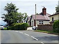
1

176 metre spot height, Margate Cross, Tirril
At the south-west edge of the village, on the B5320.
Image: © Christine Johnstone
Taken: 19 Sep 2015
0.02 miles
3
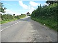
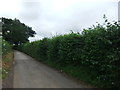
Looking east from the layby on the B5320
Heading to Tirril.
Image: © Christine Johnstone
Taken: 19 Sep 2015
0.11 miles
5
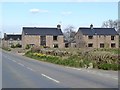
New houses at Broad Ing Farm
Beside the B5320 on the outskirts of Tirrel.
Image: © Oliver Dixon
Taken: 11 Apr 2019
0.13 miles
6
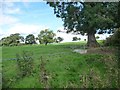
Wooded farmland, between Thorpe and Kirkbarrow
On the boundary of the Lake District National Park.
Image: © Christine Johnstone
Taken: 19 Sep 2015
0.13 miles
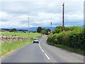
7

Looking west along the B5320
Heading to Pooley Bridge.
Image: © Christine Johnstone
Taken: 19 Sep 2015
0.15 miles
8
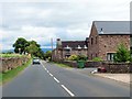
The B5320 passing new houses at Broad Ing
Image: © Steve Daniels
Taken: 5 Jul 2019
0.16 miles
10

Grassed land at periphery of Lake District National Park
The nature of this land at the north-eastern margin of the Lake District National Park is uncertain. The grass has an almost manicured appearance and to the right of the image, unseen in this view, there are trees surrounded by protective fencing. Both of those features might suggest parkland rather than farmland.
Image: © Trevor Littlewood
Taken: 26 Mar 2017
0.17 miles