IMAGES TAKEN NEAR TO
Pennine Close, PENRITH, CA10 2HS
Introduction
This page details the photographs taken nearby to Pennine Close, CA10 2HS by members of the Geograph project.
The Geograph project started in 2005 with the aim of publishing, organising and preserving representative images for every square kilometre of Great Britain, Ireland and the Isle of Man.

There are currently over 7.5m images from over14,400 individuals and you can help contribute to the project by visiting https://www.geograph.org.uk
Image Map
Images are licensed for reuse under creativecommons.org/licenses/by-sa/2.0
Notes
- Clicking on the map will re-center to the selected point.
- The higher the marker number, the further away the image location is from the centre of the postcode.
Image Listing (17 Images Found)
Images are licensed for reuse under creativecommons.org/licenses/by-sa/2.0
Image
Details
Distance

4
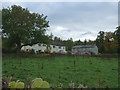
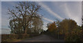
Grazing towards Lowther
View west from the A6.
Image: © JThomas
Taken: 22 Oct 2016
0.06 miles
6

Old Milepost by the A6, Hackthorpe, Lowther parish
Cast iron post by the A6, in parish of Lowther (Eden District), Northern end of Hackthorpe, under hedge, on East side of road. Winder iron casting, erected by the Heronsyke & Eamont Bridge turnpike trust in the 19th century.
Inscription reads:-
: SHAP / 6 / MILES : : 1825 : : PENRITH / 4½ / MILES :
Maker:-
: T.Winder / Gatebeck / Foundry :
Grade II listed.
List Entry Number: 1068724 https://historicengland.org.uk/listing/the-list/list-entry/1068724
Milestone Society National ID: WE_SPPR06
Image: © CF Smith
Taken: 4 Oct 2006
0.10 miles
8
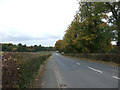
The A6
The sky is patterned with cirrus, not vapour trails
Image: © Ian Greig
Taken: 28 Oct 2011
0.13 miles
9
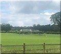
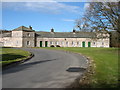
Model Village, Lowther
These estate houses were built in 1773 after drawings for a 'model' village by Robert Adam. They were (in 2002) being modernised for a housing association, reducing the number of dwellings.
Image: © Humphrey Bolton
Taken: 18 Feb 2002
0.15 miles
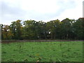
10

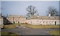
Part of the Lowther estate village
This was built in 1773, according to the listing details, although the Visit Cumbria website states that building started in 1806. It replaced much of the Lowther New Town village, which had replaced the original village. It is perhaps unusual in that each group of houses has a different shape.
Image: © Humphrey Bolton
Taken: 18 Feb 2001
0.17 miles