IMAGES TAKEN NEAR TO
Clifton, PENRITH, CA10 2EA
Introduction
This page details the photographs taken nearby to CA10 2EA by members of the Geograph project.
The Geograph project started in 2005 with the aim of publishing, organising and preserving representative images for every square kilometre of Great Britain, Ireland and the Isle of Man.

There are currently over 7.5m images from over14,400 individuals and you can help contribute to the project by visiting https://www.geograph.org.uk
Image Map
Images are licensed for reuse under creativecommons.org/licenses/by-sa/2.0
Notes
- Clicking on the map will re-center to the selected point.
- The higher the marker number, the further away the image location is from the centre of the postcode.
Image Listing (59 Images Found)
Images are licensed for reuse under creativecommons.org/licenses/by-sa/2.0
Image
Details
Distance
1
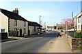
Clifton, village scene
Image: © Rose and Trev Clough
Taken: 25 Mar 2012
0.01 miles
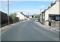
4
Clifton Village Hall - with passing train
The West Coast Main Line railway passes under the A6 at Clifton, and skirts south east round the village (see Image ).
Image: © Rose and Trev Clough
Taken: 25 Mar 2012
0.03 miles
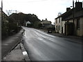
5
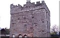
Old Church, Clifton, Penrith
I think this could be a private house? There are no signs outside and I saw a man take his dog into the building.
Image: © Malcolm Street
Taken: 19 Nov 2005
0.04 miles
6
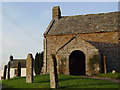
St Cuthbert's Church, Clifton
The church dates from Medieval times.
Image: © Maigheach-gheal
Taken: 4 Apr 2010
0.05 miles
8
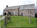
Rowan and oak at St Cuthbert's Church, Clifton
Image: © Eirian Evans
Taken: 21 Sep 2020
0.05 miles
9
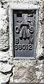
Benchmark on St Cuthbert's Church
Ordnance Survey flush bracket (serial identifier S8012) benchmark levelled in 1969 at 156.923m above Newlyn Datum
Image: © Roger Templeman
Taken: 20 Jun 2022
0.06 miles
10
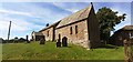
St Cuthbert's Church
There is an Ordnance Survey benchmark Image on the near corner, left hand face, of the church
Image: © Roger Templeman
Taken: 20 Jun 2022
0.07 miles