IMAGES TAKEN NEAR TO
Eamont Bridge, PENRITH, CA10 2BZ
Introduction
This page details the photographs taken nearby to CA10 2BZ by members of the Geograph project.
The Geograph project started in 2005 with the aim of publishing, organising and preserving representative images for every square kilometre of Great Britain, Ireland and the Isle of Man.

There are currently over 7.5m images from over14,400 individuals and you can help contribute to the project by visiting https://www.geograph.org.uk
Image Map
Images are licensed for reuse under creativecommons.org/licenses/by-sa/2.0
Notes
- Clicking on the map will re-center to the selected point.
- The higher the marker number, the further away the image location is from the centre of the postcode.
Image Listing (85 Images Found)
Images are licensed for reuse under creativecommons.org/licenses/by-sa/2.0
Image
Details
Distance
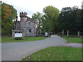
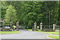
1
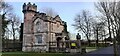
The lodge at entrance to Lowther Holiday Park
Image: © Luke Shaw
Taken: 19 Feb 2022
0.00 miles
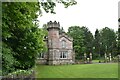
4
Lowther Lodge
Entrance to Lowther Holiday Park.
Image: © JThomas
Taken: 22 Oct 2016
0.01 miles
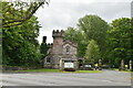
6
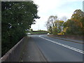
A6, Lowther Bridge
Heading north west towards Penrith.
Image: © JThomas
Taken: 22 Oct 2016
0.02 miles
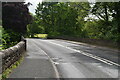
7

Benchmark on parapet of A6 bridge over River Lowther
Ordnance Survey rivet benchmark levelled at 123.788m above Newlyn Datum
Image: © Roger Templeman
Taken: 28 Mar 2022
0.02 miles

10
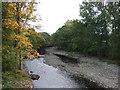
The River Lowther
View from Lowther Bridge on the A6.
Image: © JThomas
Taken: 22 Oct 2016
0.03 miles