IMAGES TAKEN NEAR TO
Old Post Office Row, PENRITH, CA10 2BS
Introduction
This page details the photographs taken nearby to Old Post Office Row, CA10 2BS by members of the Geograph project.
The Geograph project started in 2005 with the aim of publishing, organising and preserving representative images for every square kilometre of Great Britain, Ireland and the Isle of Man.

There are currently over 7.5m images from over14,400 individuals and you can help contribute to the project by visiting https://www.geograph.org.uk
Image Map
Images are licensed for reuse under creativecommons.org/licenses/by-sa/2.0
Notes
- Clicking on the map will re-center to the selected point.
- The higher the marker number, the further away the image location is from the centre of the postcode.
Image Listing (120 Images Found)
Images are licensed for reuse under creativecommons.org/licenses/by-sa/2.0
Image
Details
Distance
4
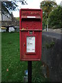
Elizabeth II postbox on the A6, Eamont Bridge
Postbox No. CA10 87.
Image: © JThomas
Taken: 22 Oct 2016
0.04 miles
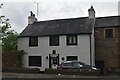
6

Old Mansion House on east side of A6
The premises of Welplan Ltd, and possibly formerly the Eamont Workhouse. There is an Ordnance Survey benchmark Image on the right hand gatepost at the entrance
Image: © Roger Templeman
Taken: 19 Feb 2022
0.04 miles
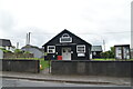
9
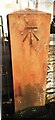
Benchmark on gatepost at entrance to Old Mansion House
Ordnance Survey cut mark benchmark levelled at 120.764m above Newlyn Datum in 1972. This appears to be the location of a benchmark levelled at 395.981 feet above Liverpool Datum during the 1GL Liverpool to Port Carlisle Survey of 1841-1844, although the gatepost may be a modern replacement. The surveyor's description was 'No. 385. Mark on South pier of Eamont Workhouse gate ; 4.44 ft. above surface of road'.
Image: © Roger Templeman
Taken: 19 Feb 2022
0.04 miles