IMAGES TAKEN NEAR TO
Kirkby Thore, PENRITH, CA10 1XD
Introduction
This page details the photographs taken nearby to CA10 1XD by members of the Geograph project.
The Geograph project started in 2005 with the aim of publishing, organising and preserving representative images for every square kilometre of Great Britain, Ireland and the Isle of Man.

There are currently over 7.5m images from over14,400 individuals and you can help contribute to the project by visiting https://www.geograph.org.uk
Image Map
Images are licensed for reuse under creativecommons.org/licenses/by-sa/2.0
Notes
- Clicking on the map will re-center to the selected point.
- The higher the marker number, the further away the image location is from the centre of the postcode.
Image Listing (25 Images Found)
Images are licensed for reuse under creativecommons.org/licenses/by-sa/2.0
Image
Details
Distance
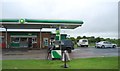
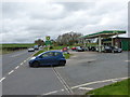
2
Filling station on the A66 at Kirkby Thore
Image: © Alpin Stewart
Taken: 12 Oct 2016
0.00 miles
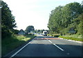
4
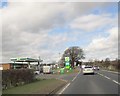
Filling station Kirkby Thore
On the A66 westbound on entering the village
Image: © Martin Dawes
Taken: 26 Mar 2018
0.01 miles
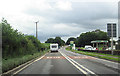
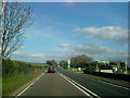
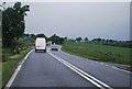
5
Petrol Station at Town End
Looking past the petrol station along the A66.
Image: © Andy Farrington
Taken: 6 Apr 2012
0.02 miles
7
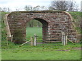
Bridge at Bridge End
Former rail bridge near to Bridge End Farm.
Image: © Andy Farrington
Taken: 6 Apr 2012
0.04 miles
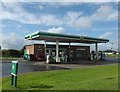
8
Filling station at Kirkby Thore on the A66
Image: © Andrew Abbott
Taken: 15 May 2010
0.04 miles
10
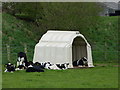
Cow Kennels
These Holsteins belonging to Bridge End Farm in Kirkby Thorpe appear well looked after with several of these shelters dotted around the field.
Image: © Andy Farrington
Taken: 6 Apr 2012
0.07 miles