IMAGES TAKEN NEAR TO
Chapel Terrace, PENRITH, CA10 1UQ
Introduction
This page details the photographs taken nearby to Chapel Terrace, CA10 1UQ by members of the Geograph project.
The Geograph project started in 2005 with the aim of publishing, organising and preserving representative images for every square kilometre of Great Britain, Ireland and the Isle of Man.

There are currently over 7.5m images from over14,400 individuals and you can help contribute to the project by visiting https://www.geograph.org.uk
Image Map
Images are licensed for reuse under creativecommons.org/licenses/by-sa/2.0
Notes
- Clicking on the map will re-center to the selected point.
- The higher the marker number, the further away the image location is from the centre of the postcode.
Image Listing (36 Images Found)
Images are licensed for reuse under creativecommons.org/licenses/by-sa/2.0
Image
Details
Distance
1
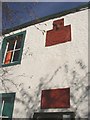
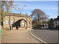
The plaques on the Forester's Hall, Kirkby Thore
The lower plaque states that the ground floor was "Erected by Subscription 1832 / scientia millaeres est praestantior". This was a reading room. The first floor was added by The Independent Order of Foresters, a fraternal benefit society. The upper plaque has a deer's head and "Foresters Hall No.844 AD 1844 / Unitas Benevolentia et Concordia".
Image: © Humphrey Bolton
Taken: 3 Nov 2006
0.02 miles
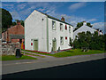
2
Forester's Hall, Kirkby Thore
This Grade II listed building was initially a single-storey reading room built in 1832. The Foresters added their first-floor room in 1844. To the left is the 18C village pound, in which is the former fire-engine house, which was built as a school lavatory in the 19C. These are also Grade II listed.
Image: © Humphrey Bolton
Taken: 3 Nov 2006
0.02 miles
3

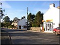
Village Stores/Post Office at Main Street / Cross Street junction
There is an OS benchmark Image on the near corner, Cross Street face, on the third black quoin above ground
Image: © Roger Templeman
Taken: 23 Jul 2015
0.02 miles
4
Foresters Hall, Kirkby Thore
This has two date stones: 'FORESTERS HALL / No, 844 / 1844'/ UNITAS BENEVOLENTIA ET CONCORDIA, surmounted by a deer's head, and 'ERECTED / BY SUBSCRIPTION / 1832 / scientia millaeres est praestantior'. The hall was first built as a single-storey reading room, according to the listing details.
Image: © Humphrey Bolton
Taken: 7 Jul 2021
0.03 miles
5

Benchmark on Village Stores and Post Office
Ordnance Survey cut mark benchmark described on the Bench Mark Database at http://www.bench-marks.org.uk/bm31954
Image: © Roger Templeman
Taken: 23 Jul 2015
0.03 miles
7
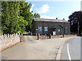
War Memorial Hall, Kirkby Thore
The foundation stone is dated 1926. The blank arches in the wall hark back to earlier centuries, but the building must have looked modern in 1926. It has the regulation ventilation turret on the roof.
Image: © Humphrey Bolton
Taken: 3 Nov 2006
0.04 miles
8
Post Office and Chippy, Kirkby Thore
Many villages have a post office, but fewer a fish and chip shop. However I have since been informed that Mr Chips has now been closed and the shop converted back to a residence.
Image: © Humphrey Bolton
Taken: 3 Nov 2006
0.06 miles
9
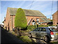
Methodist Chapel, Chapel Lane, Kirkby Thore
This little building is still in use as a chapel. Unfortunately the porch has covered the date on the sandstone plaque.
Image: © Humphrey Bolton
Taken: 3 Nov 2006
0.06 miles
10
Memorial Hall, Kirkby Thore
Built to commemorate the first World War.
Image: © Oliver Dixon
Taken: 15 Jul 2015
0.06 miles