IMAGES TAKEN NEAR TO
Temple Sowerby, PENRITH, CA10 1SW
Introduction
This page details the photographs taken nearby to CA10 1SW by members of the Geograph project.
The Geograph project started in 2005 with the aim of publishing, organising and preserving representative images for every square kilometre of Great Britain, Ireland and the Isle of Man.

There are currently over 7.5m images from over14,400 individuals and you can help contribute to the project by visiting https://www.geograph.org.uk
Image Map
Images are licensed for reuse under creativecommons.org/licenses/by-sa/2.0
Notes
- Clicking on the map will re-center to the selected point.
- The higher the marker number, the further away the image location is from the centre of the postcode.
Image Listing (19 Images Found)
Images are licensed for reuse under creativecommons.org/licenses/by-sa/2.0
Image
Details
Distance
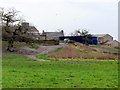
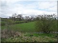
3
Williamsgill
Farmland viewed from the woods at Acorn Bank.
Image: © Ian Taylor
Taken: 16 Feb 2014
0.10 miles
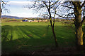
5
Farmland south-west of Newbiggin
Seen from the open window of a northbound train on the Settle Carlisle line.
Image: © Christine Johnstone
Taken: 11 Apr 2014
0.20 miles
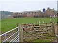
6
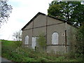
Disused building
Untouched in the last five years and not even being used agriculturally.
The string suggests it is unsafe.
Image: © David Brown
Taken: 19 Oct 2010
0.21 miles
7
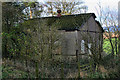
Newbarn Wood
Old barn in a wood at the side of Milburn Road.
Image: © Peter McDermott
Taken: 13 Nov 2011
0.23 miles
8
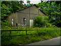
Engine House for the gypsum mine, Acorn Bank
Gypsum was mined in the estate by open-cast from 1880 and underground from 1890 The mine closed in 1938. This building looks as if it was built during the early 20C.
Image: © Humphrey Bolton
Taken: 7 Jul 2021
0.23 miles
9
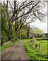
Dirt road beside Newbarn Wood
The road is heading north towards Milburn Road where a building can just be detected through foliage. The National Trust record for it describes it as an engine house associated with gypsum mining at Acorn Bank.
Image: © Trevor Littlewood
Taken: 1 May 2023
0.23 miles
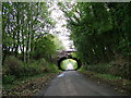
10
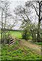
Bridge with 'fabric' covering
The farm track and bridge are both covered with some kind of material. The route begins at Williamsgill Farm which is hidden behind the trees. Crowdundle Beck flows beneath the bridge.
Image: © Trevor Littlewood
Taken: 1 May 2023
0.23 miles