IMAGES TAKEN NEAR TO
Temple Sowerby, PENRITH, CA10 1SN
Introduction
This page details the photographs taken nearby to CA10 1SN by members of the Geograph project.
The Geograph project started in 2005 with the aim of publishing, organising and preserving representative images for every square kilometre of Great Britain, Ireland and the Isle of Man.

There are currently over 7.5m images from over14,400 individuals and you can help contribute to the project by visiting https://www.geograph.org.uk
Image Map
Images are licensed for reuse under creativecommons.org/licenses/by-sa/2.0
Notes
- Clicking on the map will re-center to the selected point.
- The higher the marker number, the further away the image location is from the centre of the postcode.
Image Listing (22 Images Found)
Images are licensed for reuse under creativecommons.org/licenses/by-sa/2.0
Image
Details
Distance
1
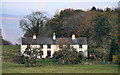
Acorn Bank Cottages
Acorn Bank Cottages seen from Milburn Road.
Image: © Peter McDermott
Taken: 13 Nov 2011
0.01 miles
2
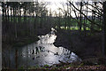
Flooded gypsum mine workings, Acorn Bank
Image: © Ian Taylor
Taken: 16 Feb 2014
0.09 miles
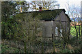
3
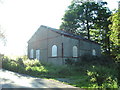
Boarded up building
Looking at the shape of the windows this building could once have been a place of worship there are no other signs as to say what its use it ever was.
Image: © Alexander P Kapp
Taken: 8 Sep 2006
0.10 miles
4
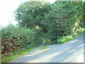
Track
Old track to Newbiggin Quarry and Mine
Image: © Alexander P Kapp
Taken: 8 Sep 2006
0.12 miles

6
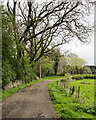
Dirt road beside Newbarn Wood
The road is heading north towards Milburn Road where a building can just be detected through foliage. The National Trust record for it describes it as an engine house associated with gypsum mining at Acorn Bank.
Image: © Trevor Littlewood
Taken: 1 May 2023
0.14 miles
7
Newbarn Wood
Old barn in a wood at the side of Milburn Road.
Image: © Peter McDermott
Taken: 13 Nov 2011
0.14 miles
8
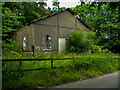
Engine House for the gypsum mine, Acorn Bank
Gypsum was mined in the estate by open-cast from 1880 and underground from 1890 The mine closed in 1938. This building looks as if it was built during the early 20C.
Image: © Humphrey Bolton
Taken: 7 Jul 2021
0.14 miles
9

The Dalston Oak, from the west, Acorn Bank estate
Acorn Bank is a National Trust property, incorporating an old house, gardens, woodland, a watermill and a disused drift mine. In the 1700s, John Dalston felled most of the oak woodland that blocked his view of the Lake District. This is one of the few trees that was not cut down. It is one of the oldest trees on the estate, certainly many centuries old.
Image: © Christine Johnstone
Taken: 12 Mar 2017
0.15 miles
10
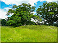
The Dalston Oak, Acorn Bank
This tree is 500 years old and has a hollow trunk; the hole can be seen as a dark upright ellipse. It was perhaps the only tree spared when Mr Dalston had the woodland cleared from in front of the house for the sake of the view.
Image: © Humphrey Bolton
Taken: 7 Jul 2021
0.15 miles