IMAGES TAKEN NEAR TO
Temple Sowerby, PENRITH, CA10 1RS
Introduction
This page details the photographs taken nearby to CA10 1RS by members of the Geograph project.
The Geograph project started in 2005 with the aim of publishing, organising and preserving representative images for every square kilometre of Great Britain, Ireland and the Isle of Man.

There are currently over 7.5m images from over14,400 individuals and you can help contribute to the project by visiting https://www.geograph.org.uk
Image Map
Images are licensed for reuse under creativecommons.org/licenses/by-sa/2.0
Notes
- Clicking on the map will re-center to the selected point.
- The higher the marker number, the further away the image location is from the centre of the postcode.
Image Listing (24 Images Found)
Images are licensed for reuse under creativecommons.org/licenses/by-sa/2.0
Image
Details
Distance
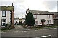
1
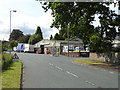
Eden Garage, Temple Sowerby
On the former A66 through the village, now by-passed.
Image: © Oliver Dixon
Taken: 15 Jul 2015
0.05 miles
2
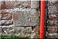
Benchmark on 'Stonehurst'
Ordnance Survey cut mark benchmark described on the Bench Mark Database at www.bench-marks.org.uk/bm68665
Image: © Luke Shaw
Taken: 4 Feb 2020
0.07 miles
3
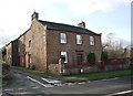
'Stonehurst' at junction of Roman Road and Vicarage Lane
There is an OS benchmark Image on the left hand side of the house left of the red downpipe
Image: © Luke Shaw
Taken: 4 Feb 2020
0.07 miles
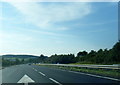
4
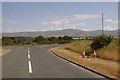
Spur, Temple Sowerby bypass
Road from the eastbound carriageway of the A66 to the old alignment with Cross Fell in the background.
Image: © Richard Webb
Taken: 7 Jul 2018
0.09 miles
5
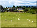
Pasture, Temple Sowerby
Sheep grazing to the south of the village.
Image: © Andrew Smith
Taken: 23 Aug 2014
0.09 miles
6
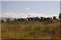
Audience, Temple Sowerby
Cattle finding me amusing. Taken from the spur linking the old A66 road with the Temple Sowerby bypass.
Image: © Richard Webb
Taken: 7 Jul 2018
0.10 miles
7
Side road between houses on SW side of main road through Temple Sowerby
Ordnance Survey documents indicate that in 1844 a benchmark was levelled at 339.841 feet above Liverpool Datum on a building at this location during the Penrith to Darlington Survey. The surveyor's description was 'No. 28. Mark on South-east corner of Scoring House, in Mr. Dixon's tan-yard ; 3.06 ft. above surface'. See www.bench-marks.org.uk/bm67388
Image: © Luke Shaw
Taken: 4 Feb 2020
0.13 miles
9
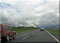
Temple Sowerby turning from A66
South of Temple Sowerby
Image: © John Firth
Taken: 29 Jul 2012
0.14 miles
10
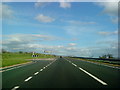
Turning for Temple Sowerby from the A66
Image: © Andrew Abbott
Taken: 15 May 2010
0.15 miles