IMAGES TAKEN NEAR TO
Culgaith, PENRITH, CA10 1QD
Introduction
This page details the photographs taken nearby to CA10 1QD by members of the Geograph project.
The Geograph project started in 2005 with the aim of publishing, organising and preserving representative images for every square kilometre of Great Britain, Ireland and the Isle of Man.

There are currently over 7.5m images from over14,400 individuals and you can help contribute to the project by visiting https://www.geograph.org.uk
Image Map
Images are licensed for reuse under creativecommons.org/licenses/by-sa/2.0
Notes
- Clicking on the map will re-center to the selected point.
- The higher the marker number, the further away the image location is from the centre of the postcode.
Image Listing (19 Images Found)
Images are licensed for reuse under creativecommons.org/licenses/by-sa/2.0
Image
Details
Distance
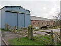
2
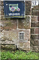
OS Flush Bracket 11748 - Mill Rigg Farm
Image: © thejackrustles
Taken: 28 Jun 2024
0.01 miles
3
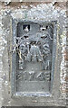
OS Flush Bracket 11748 - Mill Rigg Farm
Image: © thejackrustles
Taken: 28 Jun 2024
0.02 miles
6
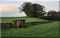
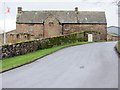
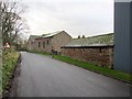
Mill Rigg
Fields near Mill Rigg Farm.
Image: © Peter McDermott
Taken: 13 Nov 2011
0.06 miles
8
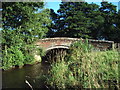
Millrigg Bridge
This red sandstone bridge carries the B6412 over Crowdundle Beck
Image: © Alexander P Kapp
Taken: 8 Sep 2006
0.10 miles
9
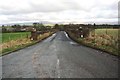
Looking along the B6412 from White Gate towards Millrigg
Image: © Roger Templeman
Taken: 4 Feb 2020
0.10 miles
