1
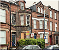
No 7 Camden Street, Belfast (May 2016)
A long-term vacant house towards the Lisburn Road end of Camden Street. Now agreed for sale and previously described by the agents as “The property comprises a residential building arranged over ground and two upper floors to provide 3no. flats comprising 2no. 1 bedroom flats on the ground floor and a 5 bedroom duplex flat on the first and second floors. The property represents an excellent redevelopment opportunity in an area of high rental demand close to Belfast City Hospital and Queens University” and “We understand that Full Planning Permission was granted on the 16th February 2012 for 5no. flats (3no. 2 bedroom flats and 2no. 1 bedroom flats) (Planning Ref: Z/2009/1135/F).”
Image: © Albert Bridge
Taken: 8 May 2016
0.01 miles
2
Ulsterbus Tours coach, Belfast
A Plaxton-bodied Volvo, in the livery of Ulsterbus Tours, making its way along the Lisburn Road, near Fitzwilliam Street.
Image: © Albert Bridge
Taken: 17 Feb 2010
0.02 miles
3
Camden Street, Belfast (2)
See
Image The northern side of the street looking towards the Lisburn Road.
Image: © Albert Bridge
Taken: 18 Oct 2007
0.02 miles
4
Camden Street, Belfast (August 2018)
See
Image (August 2007). The Lisburn Road end, looking towards the University Road. The 1880 street directory shows “1. Ferrar, Michael 3. McGeagh, R. T., ship owner ..............Abercorn Street intersects...........… Belfast Skating Rink Camden Terrace 8. Jackson, Robert 6. Clendinning, Mrs. 4. Thompson, Hugh, student 2. Arnold, Mrs.” and nothing else.
The PRONI historical map (1832/46) marks a brewery just out of picture to the left.
Image: © Albert Bridge
Taken: 5 Aug 2018
0.02 miles
5
Morris Minor, Belfast
1970 Minor 1000 convertible parked on the Lisburn Road. The “1000” originally had a 948cc engine but was later fitted with the 1098cc version.
Image: © Albert Bridge
Taken: 25 Apr 2010
0.02 miles
6
Seventh-Day Adventist church, Belfast
Seventh-Day Adventist church http://belfast.adventistchurch.org.uk/ on the Lisburn Road, near Elmwood Avenue. It might date from the 1960’s (further information welcomed). See also
Image
Image: © Albert Bridge
Taken: 29 May 2011
0.03 miles
7
Fitzwilliam Street, Belfast (August 2018)
A street, popular with students, running from the Lisburn Road to the University Road (background). The 1877 street directory shows it with only eleven houses.
Image: © Albert Bridge
Taken: 5 Aug 2018
0.04 miles
8
Russell Court, Belfast (August 2018)
See
Image May 2011. The apartments are now under the management of the Radius Housing Association (which includes the stock of the former Helm Housing Association). The imprint of the old BIH (Belfast Improved Homes) sign can still be seen at middle top.
Image: © Albert Bridge
Taken: 5 Aug 2018
0.04 miles
9
All Souls Church, Belfast (3)
See
Image The date of completion, on a metal plate attached to the oak buttress. Continue to
Image
Image: © Albert Bridge
Taken: 26 Sep 2009
0.05 miles
10
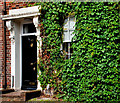
Door, window and creeper, Belfast
Door and window, surrounded by creeper, at no 85 Lisburn Road – currently vacant and offered for sale as offices.
Image: © Albert Bridge
Taken: 8 Aug 2010
0.05 miles


