
IMAGES TAKEN NEAR TO
Eglantine Avenue, BELFAST, BT9 6DW
Introduction
This page details the photographs taken nearby to Eglantine Avenue, BT9 6DW by members of the Geograph project.
The Geograph project started in 2005 with the aim of publishing, organising and preserving representative images for every square kilometre of Great Britain, Ireland and the Isle of Man.

There are currently over 7.5m images from over14,400 individuals and you can help contribute to the project by visiting https://www.geograph.org.uk
Image Map
Images are licensed for reuse under creativecommons.org/licenses/by-sa/2.0
Notes
- Clicking on the map will re-center to the selected point.
- The higher the marker number, the further away the image location is from the centre of the postcode.
Image Listing (214 Images Found)
Images are licensed for reuse under creativecommons.org/licenses/by-sa/2.0
Image
Details
Distance
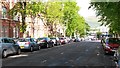
2
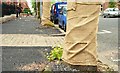
Tree protection, Belfast
Some of the trees, on the northern side of Eglantine Avenue, have hessian protection, against accidental damage, during reconstruction of the footpath.
Image: © Albert Bridge
Taken: 28 Jun 2009
0.04 miles
3
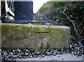
Bench Mark, Belfast
Cut bench mark located at the Lisburn Road end of Eglantine Avenue in Belfast. It lies at the bottom of a former gate pier - the stonework above has been removed and replaced by a modern metal post but the base, with bench mark, has been left. Difficult to spot and OSNI appear to have missed it out on their 2007 map (it appears on the 1970 edition).
See also http://www.geograph.org.uk/search.php?i=11037856 for many other examples I have found.
Image: © Rossographer
Taken: 4 Mar 2010
0.05 miles
4
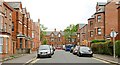
Eglantine Place, Belfast
Late 19th century street, of large terrace houses, running from Malone Avenue Image to Eglantine Avenue (background). Now partly rebuilt with modern apartments in a matching style.
Image: © Albert Bridge
Taken: 25 Jun 2009
0.06 miles
5
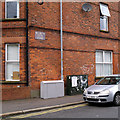
Telecommunications boxes, Belfast
Two telecommunications boxes on Wellington Park Avenue in Belfast. The one on the right has a poster on it which is seen and explained in Image
Image: © Rossographer
Taken: 17 Apr 2014
0.06 miles
6

Telecommunications box, Belfast
The telecommunications box seen in Image Since they started being installed a few years ago I'd always been curious about the sounds they emit. I'm still not sure I fully understand this, but the mysterious poster is explained at this website http://xmsbelfast.com/home . I have seen a number of these around Belfast, although the posters don't last long so need to be photographed quickly before they are removed. See also Image for a closer view of the QR code and website address at the bottom of the poster.
Image: © Rossographer
Taken: 17 Apr 2014
0.06 miles
7

Telecommunications box, Belfast
Detail of the poster seen in Image on a telecommunications box on Wellington Park Avenue in Belfast. This is the QR code and website address for this particular box http://xmsbelfast.com/box/18.
Image: © Rossographer
Taken: 17 Apr 2014
0.06 miles
8
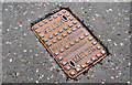
Water meter cover, Belfast
See Image A water meter cover, at the Lisburn Road end of Eglantine Avenue, also from the foundry of Guest & Chrimes, Rotherham Image
Image: © Albert Bridge
Taken: 10 Aug 2010
0.06 miles
9

Cussick Street, Belfast
Originally built around 1870, Cussick Street (on the eastern side of the Lisburn Road) has now been completely rebuilt. It seems that it once housed an unusually high number of gardeners – possibly employed in keeping the gardens of the Malone villas neat and tidy.
Image: © Albert Bridge
Taken: 15 Aug 2009
0.06 miles
10
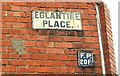
Street sign, Belfast
Enamel street and fire point signs, at the Malone Avenue end of Eglantine Place Image
Image: © Albert Bridge
Taken: 25 Jun 2009
0.06 miles