IMAGES TAKEN NEAR TO
Geneva Gardens, BELFAST, BT9 5FY
Introduction
This page details the photographs taken nearby to Geneva Gardens, BT9 5FY by members of the Geograph project.
The Geograph project started in 2005 with the aim of publishing, organising and preserving representative images for every square kilometre of Great Britain, Ireland and the Isle of Man.

There are currently over 7.5m images from over14,400 individuals and you can help contribute to the project by visiting https://www.geograph.org.uk
Image Map
Images are licensed for reuse under creativecommons.org/licenses/by-sa/2.0
Notes
- Clicking on the map will re-center to the selected point.
- The higher the marker number, the further away the image location is from the centre of the postcode.
Image Listing (205 Images Found)
Images are licensed for reuse under creativecommons.org/licenses/by-sa/2.0
Image
Details
Distance
1
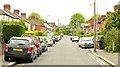
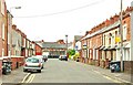
Lucerne Parade, Belfast
A street of semis running off the Lockview Road Image
Image: © Albert Bridge
Taken: 22 May 2009
0.03 miles
2
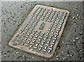
CATV access cover, Stranmillis, Belfast - April 2016(2)
A cable television (CATV) https://en.wikipedia.org/wiki/Cable_television access cover at Sharman Road, opposite Belvedere Park. No foundry name visible.
Image: © Albert Bridge
Taken: 12 Apr 2016
0.04 miles
3
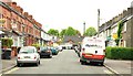
Harleston Street, Belfast
Harleston Street runs off the Lockview Road Image and like its neighbour Wansbeck Street Image, dates from around end of the 19th century. Most of the houses are not red brick – an unusual feature of streets of Victorian terrace houses in Belfast.
Image: © Albert Bridge
Taken: 22 May 2009
0.07 miles
4
Laganvale Street, Belfast
Laganvale Street is close to Wansbeck Street Image and dates from around the same time. What makes it different from its neighbour (and other Victorian streets in Belfast) is the absence of visible pitch in many of the roofs.
Image: © Albert Bridge
Taken: 22 May 2009
0.07 miles
5
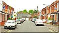
Wansbeck Street, Belfast
A street of terrace houses, running off the Lockview Road Image, dating from towards the end of the 19th century. In 1901, 16 of the 26 houses were occupied by labourers. There were also three bottle blowers living there.
Image: © Albert Bridge
Taken: 22 May 2009
0.08 miles
6
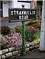
Street Sign, Belfast
Tile street sign on the Stranmillis Road in Belfast, on what is probably the original post.
Image: © Rossographer
Taken: 25 Mar 2010
0.08 miles
7
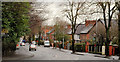
The Stranmillis Road, Belfast (4)
See Image The steep part of the road ascending from the roundabout (hidden, background). Richmond Park is marked by the white lines at lower right.
Image: © Albert Bridge
Taken: 13 Jan 2011
0.09 miles
8
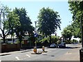
The Sharman Road junction on Stranmillis Road
This is a suburban residential area.
Image: © Eric Jones
Taken: 29 Jun 2018
0.09 miles
9
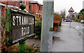
Stranmillis Road sign, Belfast
See Image This one, also a bit past its best, is on the other side of the Stranmillis Road. Richmond Park is in the background.
Image: © Albert Bridge
Taken: 13 Jan 2011
0.10 miles
10
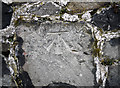
Bench Mark, Belfast
Cut bench mark on a wall along the Stranmillis Road in Belfast.
See also http://www.geograph.org.uk/search.php?i=11037856 for many other examples I have found.
Image: © Rossographer
Taken: 11 Mar 2010
0.11 miles