IMAGES TAKEN NEAR TO
Colenso Parade, BELFAST, BT9 5BB
Introduction
This page details the photographs taken nearby to Colenso Parade, BT9 5BB by members of the Geograph project.
The Geograph project started in 2005 with the aim of publishing, organising and preserving representative images for every square kilometre of Great Britain, Ireland and the Isle of Man.

There are currently over 7.5m images from over14,400 individuals and you can help contribute to the project by visiting https://www.geograph.org.uk
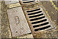
Image Map
Images are licensed for reuse under creativecommons.org/licenses/by-sa/2.0
Notes
- Clicking on the map will re-center to the selected point.
- The higher the marker number, the further away the image location is from the centre of the postcode.
Image Listing (430 Images Found)
Images are licensed for reuse under creativecommons.org/licenses/by-sa/2.0
Image
Details
Distance
1
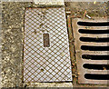
Davidson rodding cover, Belfast - May 2014(1)
See Image (Stockman’s Lane). This one is in Stranmillis Gardens Image, close to the entrance to the Queen’s PE Centre Image Image shows the maker’s name.
Image: © Albert Bridge
Taken: 17 May 2014
0.02 miles
2
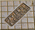
Davidson rodding cover, Belfast - May 2014(2)
See Image The maker’s name.
Image: © Albert Bridge
Taken: 17 May 2014
0.02 miles
3
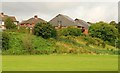
Colenso Court, Belfast
Colenso Court (shown but not named on the Google map) was one of the early apartment developments in Belfast. Built circa 1983, it overlooks the grounds of the Queen’s Physical Education Centre Image Sandhurst Drive is in the left.
Image: © Albert Bridge
Taken: 1 Sep 2009
0.02 miles
4
Colenso Parade, Belfast (2)
Image: © Albert Bridge
Taken: 4 Aug 2009
0.03 miles
5

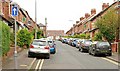
Sandhurst Gardens, Stranmillis
One of the streets leading off Stranmillis Road - mainly student accommodation for Queen's University, Belfast.
Image: © Dean Molyneaux
Taken: 9 Jul 2009
0.05 miles
6
Stewarts rodding cover, Stranmillis, Belfast - May 2014(1)
See Image A Stewarts Sandy Row Foundry rodding cover in Stranmillis Gardens Image, close to the entrance to the Queen’s PE Centre Image Image is at the top. Image shows the inscription with the maker’s name.
Image: © Albert Bridge
Taken: 17 May 2014
0.05 miles
7
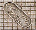
Stewarts rodding cover, Stranmillis, Belfast - May 2014(2)
See Image The inscription “Stewarts Foundry Belfast Sandy Row” showing the maker’s name.
Image: © Albert Bridge
Taken: 17 May 2014
0.05 miles
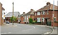
8
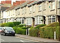
Sandhurst Drive, Belfast
Sandhurst Drive runs from Ridgeway Street to the Stranmillis Road. The view is approximately mid-way along to where it makes a sharp turn to the left. Built in the early 20th century.
Image: © Albert Bridge
Taken: 28 May 2009
0.05 miles
9
"Orlit" houses, Belfast
Orlit houses were built, using pre-cast reinforced concrete blocks, as a quick way to solve the post-WWII housing shortage. They achieved a certain notoriety with many lenders refusing to consider mortgage applications for their subsequent purchase. The scare seems to have gone the way of other scares. This row is in Stranmillis Gardens.
Image: © Albert Bridge
Taken: 7 Jul 2009
0.06 miles
10
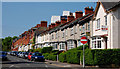
Stranmillis Gardens, Belfast
Stranmillis Gardens Image seen from the Colenso Parade end with the Orlit houses Image on the right. The non-Orlit part of the street dates from the late 19th century. Continue to Image
Image: © Albert Bridge
Taken: 22 May 2010
0.07 miles