IMAGES TAKEN NEAR TO
Irvinestown Road, ENNISKILLEN, BT94 2FE
Introduction
This page details the photographs taken nearby to Irvinestown Road, BT94 2FE by members of the Geograph project.
The Geograph project started in 2005 with the aim of publishing, organising and preserving representative images for every square kilometre of Great Britain, Ireland and the Isle of Man.

There are currently over 7.5m images from over14,400 individuals and you can help contribute to the project by visiting https://www.geograph.org.uk
Image Map
Images are licensed for reuse under creativecommons.org/licenses/by-sa/2.0
Notes
- Clicking on the map will re-center to the selected point.
- The higher the marker number, the further away the image location is from the centre of the postcode.
Image Listing (4 Images Found)
Images are licensed for reuse under creativecommons.org/licenses/by-sa/2.0
Image
Details
Distance
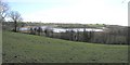
2
Trory
Various little inlets and reeded areas along the shore of Lough Erne
Image: © Kenneth Allen
Taken: 22 Mar 2007
0.08 miles
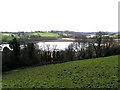
3

Trory, Enniskillen
The turnoff for the Devenish Island Ferry is to the left.
Image: © Kenneth Allen
Taken: 22 Mar 2007
0.14 miles
4
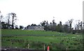
Trory Glebe House, Enniskillen
It has a commanding view of Lough Erne.
Image: © Kenneth Allen
Taken: 23 Mar 2007
0.21 miles