IMAGES TAKEN NEAR TO
Glenlevan Road, ENNISKILLEN, BT93 6AS
Introduction
This page details the photographs taken nearby to Glenlevan Road, BT93 6AS by members of the Geograph project.
The Geograph project started in 2005 with the aim of publishing, organising and preserving representative images for every square kilometre of Great Britain, Ireland and the Isle of Man.

There are currently over 7.5m images from over14,400 individuals and you can help contribute to the project by visiting https://www.geograph.org.uk
Image Map
Images are licensed for reuse under creativecommons.org/licenses/by-sa/2.0
Notes
- Clicking on the map will re-center to the selected point.
- The higher the marker number, the further away the image location is from the centre of the postcode.
Image Listing (4 Images Found)
Images are licensed for reuse under creativecommons.org/licenses/by-sa/2.0
Image
Details
Distance
1

Laneway at Tonnagh
North of the Sillees River and the village of Derrygonnelly.
Image: © Dean Molyneaux
Taken: 21 Feb 2010
0.10 miles
2
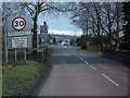
Entering Derrygonnelly
Over the Sillees River at the New Bridge.
Image: © Dean Molyneaux
Taken: 21 Feb 2010
0.14 miles
3
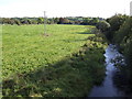
The Sillees River west of Derrygonnelly
The river flows generally south-eastwards to meet the Erne near Enniskillen.
Image: © Jonathan Billinger
Taken: 26 Sep 2007
0.17 miles
4
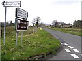
Road at Drumary
Heading north-west towards Belleek.
Image: © Kenneth Allen
Taken: 2 Apr 2008
0.23 miles