IMAGES TAKEN NEAR TO
Edenamohill Road, ENNISKILLEN, BT93 0BF
Introduction
This page details the photographs taken nearby to Edenamohill Road, BT93 0BF by members of the Geograph project.
The Geograph project started in 2005 with the aim of publishing, organising and preserving representative images for every square kilometre of Great Britain, Ireland and the Isle of Man.

There are currently over 7.5m images from over14,400 individuals and you can help contribute to the project by visiting https://www.geograph.org.uk
Image Map
Images are licensed for reuse under creativecommons.org/licenses/by-sa/2.0
Notes
- Clicking on the map will re-center to the selected point.
- The higher the marker number, the further away the image location is from the centre of the postcode.
Image Listing (11 Images Found)
Images are licensed for reuse under creativecommons.org/licenses/by-sa/2.0
Image
Details
Distance
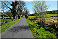
1
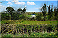
Countryside at Largy
Pictured along Killycappy Road
Image: © Kenneth Allen
Taken: 23 Apr 2022
0.11 miles
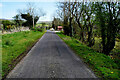
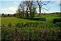
3

Farm buildings along Killycappy Road
Heading WSW at Croneen
Image: © Kenneth Allen
Taken: 11 Aug 2015
0.14 miles
4
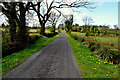
Trees along Killycappy Road
Heading west at Largy
Image: © Kenneth Allen
Taken: 23 Apr 2022
0.14 miles
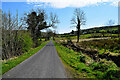
6
Killycappy Road
Heading east at Largy
Image: © Kenneth Allen
Taken: 23 Apr 2022
0.16 miles
7
Hedge and trees, Largy
Pictured along Killycappy Road
Image: © Kenneth Allen
Taken: 23 Apr 2022
0.17 miles
8
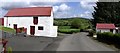
Farm Buildings near Lack
It is located a short distance to the west of the village.
Image: © Kenneth Allen
Taken: 7 May 2007
0.17 miles
9
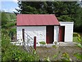
Farm Building, Lack
Wonderfully kept in good condition.
Image: © Kenneth Allen
Taken: 7 May 2007
0.17 miles
10
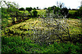
White thorn bush, Croneen
Pictured along Killycappy Road
Image: © Kenneth Allen
Taken: 23 Apr 2022
0.23 miles