IMAGES TAKEN NEAR TO
Frankhill Park, BELFAST, BT8 8PA
Introduction
This page details the photographs taken nearby to Frankhill Park, BT8 8PA by members of the Geograph project.
The Geograph project started in 2005 with the aim of publishing, organising and preserving representative images for every square kilometre of Great Britain, Ireland and the Isle of Man.

There are currently over 7.5m images from over14,400 individuals and you can help contribute to the project by visiting https://www.geograph.org.uk
Image Map
Images are licensed for reuse under creativecommons.org/licenses/by-sa/2.0
Notes
- Clicking on the map will re-center to the selected point.
- The higher the marker number, the further away the image location is from the centre of the postcode.
Image Listing (38 Images Found)
Images are licensed for reuse under creativecommons.org/licenses/by-sa/2.0
Image
Details
Distance
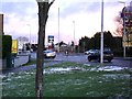
1
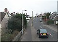
Frankhill Park, Carryduff
This is a side road off the A24 (Ballynahinch Road)
Image: © Eric Jones
Taken: 15 Feb 2012
0.03 miles
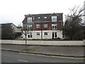
3
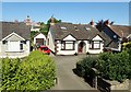
Period bungalows alongside the Belfast Road at Carryduff
Image: © Eric Jones
Taken: 29 Jun 2018
0.07 miles
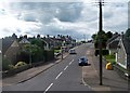
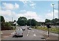
6
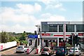
Ballynahinch Road, Carryduff
The A24 Belfast-Newcastle road passing through Carryduff - the gateway to Belfast.
Image: © Dean Molyneaux
Taken: 20 Dec 2009
0.11 miles
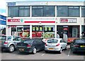
8
Apartments on Saintfield Road, Carryduff
Image: © Eric Jones
Taken: 17 Feb 2015
0.11 miles
9
Church Road, Carryduff, at its junction with the A24
Image: © Eric Jones
Taken: 10 Jul 2015
0.12 miles
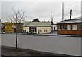
10
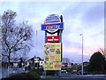
Sign, Carryduff Centre
The sign along the main A24 Belfast-Newcastle road.
Image: © Dean Molyneaux
Taken: 20 Dec 2009
0.12 miles