IMAGES TAKEN NEAR TO
Fort Road, BELFAST, BT8 8LX
Introduction
This page details the photographs taken nearby to Fort Road, BT8 8LX by members of the Geograph project.
The Geograph project started in 2005 with the aim of publishing, organising and preserving representative images for every square kilometre of Great Britain, Ireland and the Isle of Man.

There are currently over 7.5m images from over14,400 individuals and you can help contribute to the project by visiting https://www.geograph.org.uk
Image Map
Images are licensed for reuse under creativecommons.org/licenses/by-sa/2.0
Notes
- Clicking on the map will re-center to the selected point.
- The higher the marker number, the further away the image location is from the centre of the postcode.
Image Listing (3 Images Found)
Images are licensed for reuse under creativecommons.org/licenses/by-sa/2.0
Image
Details
Distance
1
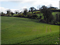
Fields near Ballylesson
Fields off the Fort Road near Ballylesson.
Image: © Rossographer
Taken: 3 Apr 2008
0.11 miles
2
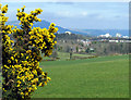
Whin bush near Ballylesson
A whin bush by a field off the Fort Road near Ballylesson. Some of the more prominent buildings of Belfast can be seen in the distance beyond.
Image: © Rossographer
Taken: 3 Apr 2008
0.21 miles
3
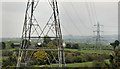
Pylons and power lines, Ballylesson, Belfast
Pylons and power lines about to cross the Fort Road near Ballylesson. They are heading towards Ballyskeagh and Lambeg Image Their origin is not quite so easy to determine. The 1:50,000 map shows a group of pylons on the Manse Road, Castlereagh. This link http://www.soni.ltd.uk/aboutus.htm has much information about the NI grid – all of which is way above my limited brain power.
Image: © Albert Bridge
Taken: 18 May 2012
0.22 miles