IMAGES TAKEN NEAR TO
Ballycoan Road, BELFAST, BT8 8LP
Introduction
This page details the photographs taken nearby to Ballycoan Road, BT8 8LP by members of the Geograph project.
The Geograph project started in 2005 with the aim of publishing, organising and preserving representative images for every square kilometre of Great Britain, Ireland and the Isle of Man.

There are currently over 7.5m images from over14,400 individuals and you can help contribute to the project by visiting https://www.geograph.org.uk
Image Map
Images are licensed for reuse under creativecommons.org/licenses/by-sa/2.0
Notes
- Clicking on the map will re-center to the selected point.
- The higher the marker number, the further away the image location is from the centre of the postcode.
Image Listing (5 Images Found)
Images are licensed for reuse under creativecommons.org/licenses/by-sa/2.0
Image
Details
Distance
1
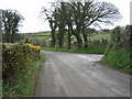
Moorcroft Road (right) joins Ballycoan Road.
Looking towards Purdysburn.
Image: © Brian Shaw
Taken: 22 Mar 2007
0.09 miles
2
![Ballycoan Road near Carryduff [4]](https://s3.geograph.org.uk/photos/79/15/791523_689369b3_120x120.jpg)
Ballycoan Road near Carryduff [4]
North east from where Image was taken.
Image: © Rossographer
Taken: 7 May 2008
0.21 miles
3
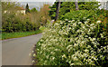
Spring verge, Purdysburn, Belfast
A spring verge of what, I think, is a member of the cow parsley family, on the Ballycoan Road near the Mill Road West (out of picture to the right).
Image: © Albert Bridge
Taken: 18 May 2012
0.24 miles
4
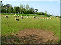
Sheep off the Ballycoan Road
Sheep in a field by Image
Image: © Rossographer
Taken: 7 May 2008
0.24 miles
5
![Sheep off the Ballycoan Road [2]](https://s1.geograph.org.uk/photos/79/15/791585_bd5bfaa5_120x120.jpg)
Sheep off the Ballycoan Road [2]
More sheep in a field by Image
Image: © Rossographer
Taken: 7 May 2008
0.24 miles