IMAGES TAKEN NEAR TO
Ballynahatty Road, BELFAST, BT8 8LE
Introduction
This page details the photographs taken nearby to Ballynahatty Road, BT8 8LE by members of the Geograph project.
The Geograph project started in 2005 with the aim of publishing, organising and preserving representative images for every square kilometre of Great Britain, Ireland and the Isle of Man.

There are currently over 7.5m images from over14,400 individuals and you can help contribute to the project by visiting https://www.geograph.org.uk
Image Map
Images are licensed for reuse under creativecommons.org/licenses/by-sa/2.0
Notes
- Clicking on the map will re-center to the selected point.
- The higher the marker number, the further away the image location is from the centre of the postcode.
Image Listing (139 Images Found)
Images are licensed for reuse under creativecommons.org/licenses/by-sa/2.0
Image
Details
Distance
1
The lane to the Giant's Ring, Belfast (1)
The access to the car park at the Giant’s Ring Image and Image is by this lane from the Ballynahatty Road Image (behind me).
Image: © Albert Bridge
Taken: 24 Feb 2012
0.03 miles
2
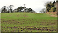
Field near the Giant's Ring, Belfast (2)
See Image Part of the same field, on the northern side of the Ballynahatty Road, near the entrance to the Giant’s Ring.
Image: © Albert Bridge
Taken: 24 Feb 2012
0.04 miles
3
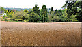
Barley field near the Giant's Ring, Belfast (3)
Part of a field of ripening barley, between the Giant’s Ring Road and the Ballynahatty Road (right).
Image: © Albert Bridge
Taken: 19 Aug 2011
0.04 miles
4

Flytipping near the Giant's Ring, Belfast
In almost six years of wandering about taking photographs for Geograph I have, from time to time, encountered minor examples of the fly-tipper’s art. This piece, off the Ballynahatty Road, close to this stile Image, was, by far, the worst. Less than a minute later the Lisburn Council lorry arrived to remove it. See also Image
Image: © Albert Bridge
Taken: 24 Feb 2012
0.05 miles
5
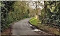
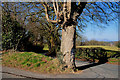
The Ballynahatty Road near the Giant's Ring, Belfast (2)
The narrow Ballynahatty Road, heading towards the Ballylesson Road, just past the lane to the Giant’s Ring. Much of this square is public road, National Trust and the Lagan Valley Regional Park with full public access for pedestrians. The lane, branching off to the left, is an exception.
Image: © Albert Bridge
Taken: 19 Aug 2011
0.05 miles
6
The Giant's Ring Road, Belfast (3)
The Giant’s Ring Road with the Ballynahatty Road in the foreground. Just about everything (except the roads) is National Trust property.
Image: © Albert Bridge
Taken: 8 Mar 2010
0.05 miles
7
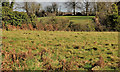
Field near the Giant's Ring, Belfast (3)
Part of a field on the western side of the lane to the Giant’s Ring Image The growth of the grass might give an indication of just how mild this winter has been.
Image: © Albert Bridge
Taken: 24 Feb 2012
0.06 miles
8
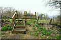
Stile near the Giant's Ring, Belfast (3)
A stile leading to the Sandpit Field Image from a track off the Ballynahatty Road.
Image: © Albert Bridge
Taken: 2 Apr 2010
0.06 miles
9
Rural "Pedestrians Ahead" sign near Belfast
“Pedestrians ahead” sign on the Ballynahatty Road, at the corner of the Giant’s Ring Road. This section of road is used when doing the circular Minnowburn walk from the Edenderry Road/Minnowburn Bridge Image by way of the Ballylesson Road Image and Giant’s Ring Road Image to Edenderry village Image and along the Lagan towpath Image
Image: © Albert Bridge
Taken: 17 Apr 2010
0.06 miles
10
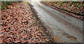
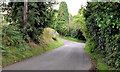
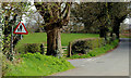
The narrow Ballynahatty Road, Belfast
The Ballynahatty Road is a narrow road running from the Giant’s Ring Road Image (hidden in the background) to the Edenderry Road. This part is too narrow to allow two cars to cross. See also Image
Image: © Albert Bridge
Taken: 28 Dec 2010
0.06 miles