IMAGES TAKEN NEAR TO
Mealough Road, BELFAST, BT8 8HP
Introduction
This page details the photographs taken nearby to Mealough Road, BT8 8HP by members of the Geograph project.
The Geograph project started in 2005 with the aim of publishing, organising and preserving representative images for every square kilometre of Great Britain, Ireland and the Isle of Man.

There are currently over 7.5m images from over14,400 individuals and you can help contribute to the project by visiting https://www.geograph.org.uk
Image Map
Images are licensed for reuse under creativecommons.org/licenses/by-sa/2.0
Notes
- Clicking on the map will re-center to the selected point.
- The higher the marker number, the further away the image location is from the centre of the postcode.
Image Listing (2 Images Found)
Images are licensed for reuse under creativecommons.org/licenses/by-sa/2.0
Image
Details
Distance
1
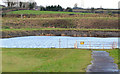
Knockbracken reservoir, Carryduff (1)
Knockbracken, reservoir, between the Mealough and Saintfield Roads, was completed in 1901 as part of a much bigger scheme (1891-1901) to bring drinking water to Belfast from the Mournes. The engineer for the Belfast Water Commissioners project was Luke Macassey Image Now disused, it had a capacity for 100 million gallons. This is the south eastern end seen from the Mealough Road. The satellite photograph shows its unusual shape.
Image: © Albert Bridge
Taken: 31 Dec 2012
0.17 miles
2
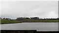
View south-westwards across the Knockbracken/Mealough Reservoir
Property on the high land overlooking the reservoir is much sought after.
Image: © Eric Jones
Taken: 12 Mar 2011
0.24 miles