IMAGES TAKEN NEAR TO
Saintfield Road, BELFAST, BT8 8EP
Introduction
This page details the photographs taken nearby to Saintfield Road, BT8 8EP by members of the Geograph project.
The Geograph project started in 2005 with the aim of publishing, organising and preserving representative images for every square kilometre of Great Britain, Ireland and the Isle of Man.

There are currently over 7.5m images from over14,400 individuals and you can help contribute to the project by visiting https://www.geograph.org.uk
Image Map
Images are licensed for reuse under creativecommons.org/licenses/by-sa/2.0
Notes
- Clicking on the map will re-center to the selected point.
- The higher the marker number, the further away the image location is from the centre of the postcode.
Image Listing (6 Images Found)
Images are licensed for reuse under creativecommons.org/licenses/by-sa/2.0
Image
Details
Distance
1
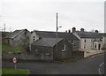
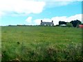
Farmhouse at the junction of Old Saintfield Road and Saintfield Road
Image: © Eric Jones
Taken: 15 Feb 2012
0.09 miles
2
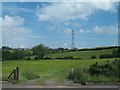
Pylons in the Belfast Green Belt
The image was taken from the A24 between Carryduff and Newtownbreda.
Image: © Eric Jones
Taken: 10 Jul 2015
0.11 miles
3
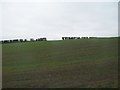
Farmland between Cairnshill and Carryduff
This view is taken from the A24.
Image: © Eric Jones
Taken: 15 Feb 2012
0.16 miles
4
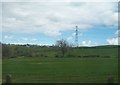
Powerlines east of the A24 (Saintfield Road)
Image: © Eric Jones
Taken: 27 Apr 2012
0.16 miles
5
Farmhouse above the A24 between Purdeysburn and Carryduff
Image: © Eric Jones
Taken: 27 Apr 2012
0.18 miles
6
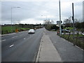
Old Saintfield Road joins the A24 Downpatrick road.
The A24 goes to Downpatrick via Saintfield and Crossgar.
Image: © Brian Shaw
Taken: 22 Mar 2007
0.19 miles