IMAGES TAKEN NEAR TO
Killynure Avenue, BELFAST, BT8 8ED
Introduction
This page details the photographs taken nearby to Killynure Avenue, BT8 8ED by members of the Geograph project.
The Geograph project started in 2005 with the aim of publishing, organising and preserving representative images for every square kilometre of Great Britain, Ireland and the Isle of Man.

There are currently over 7.5m images from over14,400 individuals and you can help contribute to the project by visiting https://www.geograph.org.uk
Image Map
Images are licensed for reuse under creativecommons.org/licenses/by-sa/2.0
Notes
- Clicking on the map will re-center to the selected point.
- The higher the marker number, the further away the image location is from the centre of the postcode.
Image Listing (8 Images Found)
Images are licensed for reuse under creativecommons.org/licenses/by-sa/2.0
Image
Details
Distance
1
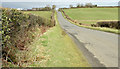
The Killynure Road, Carryduff (February 2015)
A straight and undulating part of the Killynure Road, approaching Carryduff. The road is quiet with wide verges making it reasonably safe for pedestrians. The 30 mph zone Image is near the top of the photograph.
Image: © Albert Bridge
Taken: 18 Feb 2015
0.18 miles
2
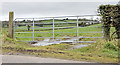
Field gate, Carryduff - February 2015(1)
A field gate, close to here Image, on the western side of the Killynure Road. The drumlins (background) are a standard feature of the scenery in this part of north Down.
Image: © Albert Bridge
Taken: 18 Feb 2015
0.18 miles
3
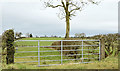
Field gate, Carryduff - February 2015(2)
A field gate, with a background of drumlins, on the western side of the Killynure Road. The tree might be an example of what was once part of an overgrown hedge – something not so likely to happen now that horizontal cutting is a standard practice.
Image: © Albert Bridge
Taken: 18 Feb 2015
0.18 miles
4
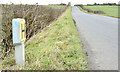
Fire hydrant post, Carryduff (February 2015)
A fire hydrant marker post on the western side of the Killynure Road.
Image: © Albert Bridge
Taken: 18 Feb 2015
0.19 miles
5
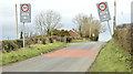
30 mph signs, Carryduff (February 2015)
The 30 mph speed limit signs entering Carryduff, from the Saintfield direction, on the Killynure Road.
Image: © Albert Bridge
Taken: 18 Feb 2015
0.19 miles
6
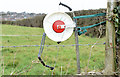
Electric fence, Carryduff (February 2015)
An electric fence and reel on the western side of the Killynure Road.
Image: © Albert Bridge
Taken: 18 Feb 2015
0.20 miles
7
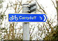
Cycle route signs, Carryduff (February 2015)
Two cycle route signs at the Killynure Road end of Killynure Avenue. Both are minor roads with light traffic.
Image: © Albert Bridge
Taken: 18 Feb 2015
0.22 miles
8
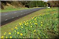
The Saintfield Road, Carryduff
The Downpatrick/Saintfield road as it approaches Carryduff. Carryduff now marks the start of greater Belfast.
Image: © Albert Bridge
Taken: 27 Mar 2008
0.23 miles