IMAGES TAKEN NEAR TO
Whinnyhill Drive, BELFAST, BT8 8BA
Introduction
This page details the photographs taken nearby to Whinnyhill Drive, BT8 8BA by members of the Geograph project.
The Geograph project started in 2005 with the aim of publishing, organising and preserving representative images for every square kilometre of Great Britain, Ireland and the Isle of Man.

There are currently over 7.5m images from over14,400 individuals and you can help contribute to the project by visiting https://www.geograph.org.uk
Image Map
Images are licensed for reuse under creativecommons.org/licenses/by-sa/2.0
Notes
- Clicking on the map will re-center to the selected point.
- The higher the marker number, the further away the image location is from the centre of the postcode.
Image Listing (25 Images Found)
Images are licensed for reuse under creativecommons.org/licenses/by-sa/2.0
Image
Details
Distance
1
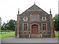
Ballycairn Presbyterian Church
Built of regular basalt with sandstone facings.
Image: © Brian Shaw
Taken: 24 Sep 2005
0.12 miles
2
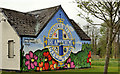
"Dreamscheme" mural, Belfast
A “Dreamscheme” (community scheme) mural near Ballycairn Drive on the Milltown Road.
Image: © Albert Bridge
Taken: 3 May 2012
0.13 miles
3
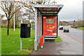
Bus shelter, Belvoir, Belfast
A bus shelter, on the Milltown Road, close to Milltown Hill. It replaced this one Image
Image: © Albert Bridge
Taken: 15 Jan 2014
0.14 miles
4
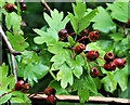
Haws, Ballylesson, Belfast
Part of an abundant display of haws, on a bush, along the Ballylesson Road Image
Image: © Albert Bridge
Taken: 21 Jun 2011
0.14 miles
5
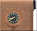
Clock, Belvoir, Belfast
A clock on premises facing the Milltown Road.
Image: © Albert Bridge
Taken: 15 Jan 2014
0.15 miles
6
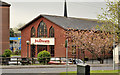
Milltown church, Belfast
Modern Baptist church, close to the Belvoir estate, between the Old Milltown Road (foreground) and the Milltown Road.
Image: © Albert Bridge
Taken: 3 May 2012
0.15 miles
7
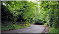
The Ballylesson Road, Belfast (10)
A bend in the Ballylesson Road, looking towards Belfast, close to Ballycairn Presbyterian church Image and Image
Image: © Albert Bridge
Taken: 21 Jun 2011
0.16 miles
8
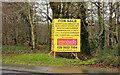
Former Belvoir Hospital site, Belfast (1)
The agents’ board facing the Milltown Road.
Image: © Albert Bridge
Taken: 15 Jan 2014
0.17 miles
9
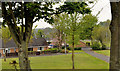
Drumcairn Close, Belfast
A well-landscaped group of bungalows on the southern side of the Milltown Road.
Image: © Albert Bridge
Taken: 3 May 2012
0.17 miles
10
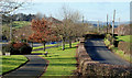
The Old Milltown Road, Belfast
The Old Milltown Road (right), once a country road south east of Belfast and now bypassed by the Milltown Road Image (left). The Belvoir estate is out of picture on the right. Image shows the western end of the road.
Image: © Albert Bridge
Taken: 8 Feb 2010
0.18 miles