IMAGES TAKEN NEAR TO
Belfast Road, BELFAST, BT8 8AS
Introduction
This page details the photographs taken nearby to Belfast Road, BT8 8AS by members of the Geograph project.
The Geograph project started in 2005 with the aim of publishing, organising and preserving representative images for every square kilometre of Great Britain, Ireland and the Isle of Man.

There are currently over 7.5m images from over14,400 individuals and you can help contribute to the project by visiting https://www.geograph.org.uk
Image Map
Images are licensed for reuse under creativecommons.org/licenses/by-sa/2.0
Notes
- Clicking on the map will re-center to the selected point.
- The higher the marker number, the further away the image location is from the centre of the postcode.
Image Listing (3 Images Found)
Images are licensed for reuse under creativecommons.org/licenses/by-sa/2.0
Image
Details
Distance
1
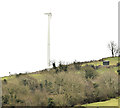
Wind turbine, Killinure near Carryduff - February 2015(1)
A wind turbine, in the townland of Killinure, visible from the Killynure Road. Information obtained from the internet suggest that it has an output of 225 kW, a height of 37 metres and 27 metres rotor diameter. The blades marge against the sky in this photograph. Image from further south along the Killynure Road gives a better impression of the size of the blades.
Image: © Albert Bridge
Taken: 18 Feb 2015
0.18 miles
2
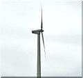
Wind turbine, Killinure near Carryduff - February 2015(2)
See Image The same turbine from further south along the Killynure Road – a view giving a better impression of the size of the blades.
Image: © Albert Bridge
Taken: 18 Feb 2015
0.18 miles