IMAGES TAKEN NEAR TO
Bests Hill Lane, BELFAST, BT8 7WB
Introduction
This page details the photographs taken nearby to Bests Hill Lane, BT8 7WB by members of the Geograph project.
The Geograph project started in 2005 with the aim of publishing, organising and preserving representative images for every square kilometre of Great Britain, Ireland and the Isle of Man.

There are currently over 7.5m images from over14,400 individuals and you can help contribute to the project by visiting https://www.geograph.org.uk
Image Map
Images are licensed for reuse under creativecommons.org/licenses/by-sa/2.0
Notes
- Clicking on the map will re-center to the selected point.
- The higher the marker number, the further away the image location is from the centre of the postcode.
Image Listing (2 Images Found)
Images are licensed for reuse under creativecommons.org/licenses/by-sa/2.0
Image
Details
Distance
1
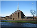
Church of the Transfiguration
This Church of Ireland Parish Church in Belvoir Estate has Three clergy.
Image: © Brian Shaw
Taken: 28 Nov 2005
0.11 miles
2
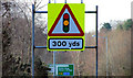
Traffic signals ahead sign, Belfast
On the Belvoir Road, at Hydebank with Image in the background. The lights Image here are approached by a bend and could surprise those not used to the road.
Image: © Albert Bridge
Taken: 8 Feb 2010
0.23 miles