IMAGES TAKEN NEAR TO
Beaufort Crescent, BELFAST, BT8 7UA
Introduction
This page details the photographs taken nearby to Beaufort Crescent, BT8 7UA by members of the Geograph project.
The Geograph project started in 2005 with the aim of publishing, organising and preserving representative images for every square kilometre of Great Britain, Ireland and the Isle of Man.

There are currently over 7.5m images from over14,400 individuals and you can help contribute to the project by visiting https://www.geograph.org.uk
Image Map
Images are licensed for reuse under creativecommons.org/licenses/by-sa/2.0
Notes
- Clicking on the map will re-center to the selected point.
- The higher the marker number, the further away the image location is from the centre of the postcode.
Image Listing (11 Images Found)
Images are licensed for reuse under creativecommons.org/licenses/by-sa/2.0
Image
Details
Distance
1
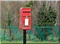
Letter box, Newtownbreda, Belfast
Post-mounted EIIR letter box (BT8 872) at Beaufort Avenue, off the Beechill Road.
Image: © Albert Bridge
Taken: 31 Dec 2012
0.11 miles
2
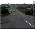
Beechill Road, Belfast
Looking up from the Newtownbreda Road.
Image: © Rossographer
Taken: 25 Jan 2008
0.12 miles
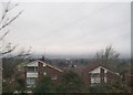
4
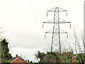
Pylon and power lines, Newtownbreda, Belfast
A pylon and power lines behind Berkley Court. They are a continuation, across the Belvoir Road Image, from Image
Image: © Albert Bridge
Taken: 31 Dec 2012
0.22 miles
5
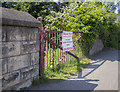
BWC gate, Belfast
Large style Belfast & District Water Commissioners gate outside an old (and almost certainly disused) valve well on the Saintfield Road in Belfast. The left gatepost had no BWC inscription, the right post was completely covered by foliage.
This appears to be the furthest set of BWC gates from the Silent Valley Image; from here the pipeline continued into the city along the Saintfield Road and then the Ravenhill Road - I can trace it was far as the eastern side of Ormeau Park but then it disappears from maps.
Image: © Rossographer
Taken: 29 May 2016
0.22 miles
6
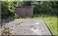
Valve well, Belfast
Belfast & District Water Commissioners old (and almost certainly disused) valve well on the Saintfield Road in Belfast.
Image: © Rossographer
Taken: 29 May 2016
0.22 miles
7
The Saintfield Road, Belfast (3)
The previous (left) and present alignments of the Saintfield Road, close to Lenaghan Avenue (behind me).
Image: © Albert Bridge
Taken: 21 Sep 2011
0.23 miles
8
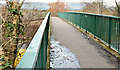
Footbridge, Newtownbreda, Belfast
A footbridge, across the Belvoir Road, connecting the Newtownbreda Road (behind me) to the Belvoir estate and forest. The road opened in 1959.
Image: © Albert Bridge
Taken: 31 Dec 2012
0.23 miles
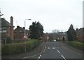
9
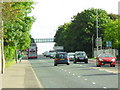
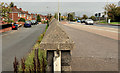
Saintfield Road at Lenaghan Park, Belfast
Looking up the Saintfield Road countrybound. Although it's the evening rush hours, there seems to be more cars heading into the city than out (no doubt caused by the lengthy traffic lights further back at Newton Park).
Image: © Dean Molyneaux
Taken: 24 Sep 2009
0.24 miles