IMAGES TAKEN NEAR TO
Belvoir Drive, BELFAST, BT8 7QT
Introduction
This page details the photographs taken nearby to Belvoir Drive, BT8 7QT by members of the Geograph project.
The Geograph project started in 2005 with the aim of publishing, organising and preserving representative images for every square kilometre of Great Britain, Ireland and the Isle of Man.

There are currently over 7.5m images from over14,400 individuals and you can help contribute to the project by visiting https://www.geograph.org.uk
Image Map
Images are licensed for reuse under creativecommons.org/licenses/by-sa/2.0
Notes
- Clicking on the map will re-center to the selected point.
- The higher the marker number, the further away the image location is from the centre of the postcode.
Image Listing (31 Images Found)
Images are licensed for reuse under creativecommons.org/licenses/by-sa/2.0
Image
Details
Distance
1
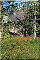
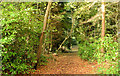
House in the Woods
Near Lagan Meadows.
Image: © Mick Garratt
Taken: 13 Sep 2009
0.03 miles
2
Belvoir forest, Belfast (2)
See Image The view, away from the Shaw’s Bridge direction, to the east of the previous photo. Continue to Image
Image: © Albert Bridge
Taken: 30 Sep 2009
0.07 miles
3
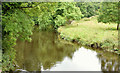
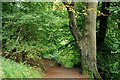
The River Lagan, Belvoir forest, Belfast (August 2014)
Some of the paths in the forest rise well above the Lagan giving, as in this case, an elevated view of one of the many bends in the river as it nears the end of its journey from Slieve Croob Image
Image: © Albert Bridge
Taken: 8 Aug 2014
0.08 miles
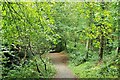
4
Path, Belvoir forest, Belfast - August 2014(1)
Part of the path from which this view Image was taken. The Lagan is hidden, well below to the left.
Image: © Albert Bridge
Taken: 8 Aug 2014
0.08 miles
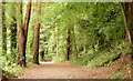
5
Path, Belvoir Forest, Belfast (October 2014)
With much of the forest felled because of the tree disease phytophthora ramorum Image traditional woodland/forest paths are not quite as common as before. Many remain - in this case fallen autumn leaves contrast with evergreen foliage.
Image: © Albert Bridge
Taken: 18 Oct 2014
0.11 miles
6
Belvoir forest, Belfast (1)
Belvoir forest is some 185 acres of woodland, in south/south east Belfast, between the Lagan and Newtownbreda. It opened in 1961. The plans for a motorway through it seem to have been abandoned. In this view the path is quite high above the Lagan (well hidden in the valley to the right), close to the entrance from the towpath near the Red Bridge Image (The Google map and the 1:12,000 OS map differ). Continue to Image
Image: © Albert Bridge
Taken: 30 Sep 2009
0.11 miles
7
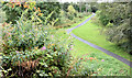
Paths, Belvoir forest, Belfast (August 2014)
Two paths, close to the car park, seen from the top of Belvoir motte. The one on the right leads towards the Lagan.
Image: © Albert Bridge
Taken: 8 Aug 2014
0.12 miles
8
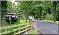
The entrance to Belvoir Forest, Belfast (August 2014)
The vehicle entrance to Belvoir Forest, off Belvoir Drive. There are also several pedestrian entrances from the Lagan towpath.
Image: © Albert Bridge
Taken: 8 Aug 2014
0.12 miles
9
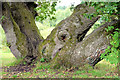
An oak tree with four trunks, Belvoir forest, Belfast (August 2014)
An oak tree, with four trunks, between the motte and the car park. Apparently this is a natural occurrence though I can’t remember ever seeing one which is quite so conspicuous.
Image: © Albert Bridge
Taken: 8 Aug 2014
0.12 miles
10
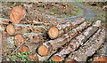
Felled trees, Belvoir Forest, Belfast (October 2014)
See Image More felled trees.
Image: © Albert Bridge
Taken: 18 Oct 2014
0.15 miles