IMAGES TAKEN NEAR TO
Belvoir Drive, BELFAST, BT8 7DQ
Introduction
This page details the photographs taken nearby to Belvoir Drive, BT8 7DQ by members of the Geograph project.
The Geograph project started in 2005 with the aim of publishing, organising and preserving representative images for every square kilometre of Great Britain, Ireland and the Isle of Man.

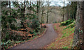
There are currently over 7.5m images from over14,400 individuals and you can help contribute to the project by visiting https://www.geograph.org.uk
Image Map
Images are licensed for reuse under creativecommons.org/licenses/by-sa/2.0
Notes
- Clicking on the map will re-center to the selected point.
- The higher the marker number, the further away the image location is from the centre of the postcode.
Image Listing (59 Images Found)
Images are licensed for reuse under creativecommons.org/licenses/by-sa/2.0
Image
Details
Distance
1
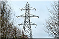
Pylon near Shaw's Bridge, Belfast (3)
See Image 1h20mins later, the same pylon, in better light, from the other side.
Image: © Albert Bridge
Taken: 13 Dec 2010
0.07 miles
2
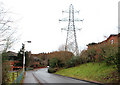
Pylon near Shaw's Bridge, Belfast (2)
See Image This is the next pylon, to the east, after the lines have crossed the Milltown Road Image The lines continue towards east Belfast and north Down. Image is on the left. See also Image
Image: © Albert Bridge
Taken: 13 Dec 2010
0.07 miles
3
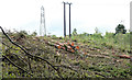
Felled trees, Belvoir forest, Belfast - August 2014(2)
See Image Felled trees near the entrance at Lockkeeper’s Lane.
Image: © Albert Bridge
Taken: 23 Aug 2014
0.15 miles
4
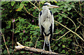
Heron, Belfast
Standing over 3ft tall, in what looks like a cloak of grey feathers, the heron might appear languid and haughty but is always watchful for food and potential predators. Herring gulls, in particular, seem to dislike it. This one was on a dead branch on the Stranmillis side of the Red Bridge Image
Image: © Albert Bridge
Taken: 20 Sep 2012
0.16 miles
5
Belvoir forest, Belfast (9)
A path, in Belvoir forest, on high ground to the south the Lagan (out of picture in the valley on the left).
Image: © Albert Bridge
Taken: 13 Dec 2010
0.17 miles
6
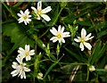
Wildflowers by the Lagan (2)
Lesser stitchwort growing beside the towpath on the Belfast side of the Red Bridge Image
Image: © Albert Bridge
Taken: 28 Apr 2008
0.18 miles
7
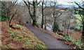
Belvoir forest, Belfast (8)
A path, in Belvoir forest, on the southern side of the Lagan. The Red Bridge Image, hidden by the trees, is a middle/right.
Image: © Albert Bridge
Taken: 13 Dec 2010
0.19 miles
8
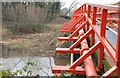
The Red Bridge, River Lagan, Belfast
The Red Bridge crosses the Lagan close to the Belfast end of the old Lock no 3 Image The remains of the canal can be seen at middle left. The view is towards Lisburn.
Image: © Albert Bridge
Taken: 16 Jan 2008
0.19 miles
9
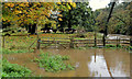
Flood near Moreland's Meadow, Belfast
Extensive flooding in the area between the canal (out of picture to the left), Moreland’s Meadow and the Lagan (middle right).
Image: © Albert Bridge
Taken: 18 Oct 2012
0.19 miles
10
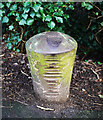
Bollard, Lagan towpath
Single bollard on the Lagan towpath close to the red bridge Image If dating from the time of the Lagan Navigation, the cuts on the side and top could well have been made by ropes continually cutting into the bollard - perhaps something akin to Image and Image?
Image: © Rossographer
Taken: 16 Dec 2009
0.19 miles