IMAGES TAKEN NEAR TO
Castleboy Avenue, BELFAST, BT8 7BD
Introduction
This page details the photographs taken nearby to Castleboy Avenue, BT8 7BD by members of the Geograph project.
The Geograph project started in 2005 with the aim of publishing, organising and preserving representative images for every square kilometre of Great Britain, Ireland and the Isle of Man.

There are currently over 7.5m images from over14,400 individuals and you can help contribute to the project by visiting https://www.geograph.org.uk
Image Map
Images are licensed for reuse under creativecommons.org/licenses/by-sa/2.0
Notes
- Clicking on the map will re-center to the selected point.
- The higher the marker number, the further away the image location is from the centre of the postcode.
Image Listing (12 Images Found)
Images are licensed for reuse under creativecommons.org/licenses/by-sa/2.0
Image
Details
Distance
1
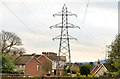
Pylons and power lines, Belvoir, Belfast
Pylons and power lines in the Belvoir estate. The one nearest the camera is behind the houses at Castlecoole Park. They are a continuation, (approximately) north east from Image and cross the Belvoir Road Image to here Image
Image: © Albert Bridge
Taken: 31 Dec 2012
0.10 miles
2
![Belvoir Road, Belfast [2]](https://s3.geograph.org.uk/photos/66/72/667203_3ef01e76_120x120.jpg)
Belvoir Road, Belfast [2]
The view of the Belvoir Road in the opposite direction to Image, this time looking south towards Lisburn.
Image: © Rossographer
Taken: 25 Jan 2008
0.15 miles
3
![Tesco, Newtownbreda [2]](https://s1.geograph.org.uk/photos/66/72/667209_f0f424e7_120x120.jpg)
Tesco, Newtownbreda [2]
Another view of the supermarket.
Image: © Rossographer
Taken: 25 Jan 2008
0.20 miles
4

Lords and ladies, Belvoir Forest, Belfast (October 2014)
One of two small examples, of the lords and ladies plant, still surviving in mid-October.
Image: © Albert Bridge
Taken: 18 Oct 2014
0.20 miles
5
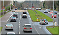
The Belvoir Road, Belfast (2)
The first part of the Belfast outer ring road, between the Saintfield Road (now “Forestside” and originally “Supermac”) and Knock, to open - back in 1959. The view is towards the former from this footbridge Image The gap (right) allows traffic to turn right into the Belvoir estate.
Image: © Albert Bridge
Taken: 31 Dec 2012
0.21 miles
6
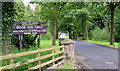
The entrance to Belvoir Forest, Belfast (August 2014)
The vehicle entrance to Belvoir Forest, off Belvoir Drive. There are also several pedestrian entrances from the Lagan towpath.
Image: © Albert Bridge
Taken: 8 Aug 2014
0.21 miles
7
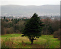
Tree, Belvoir
A tree on the edge of Belvoir Forest Park http://www.forestserviceni.gov.uk/index/forests-in-northern-ireland/forests-in-the-east-district/belvoir-park-forest.htm
Image: © Rossographer
Taken: 25 Jan 2008
0.22 miles
8
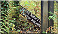
"Horse riding" sign, Belvoir Forest, Belfast (October 2014)
A fallen “horse riding is strictly prohibited” sign at a side entrance to the forest.
Image: © Albert Bridge
Taken: 18 Oct 2014
0.23 miles
9
![Tesco Newtownbreda [1]](https://s2.geograph.org.uk/photos/66/72/667206_9b1ca4d2_120x120.jpg)
Tesco Newtownbreda [1]
Yet another Tesco, this one in Newtownbreda in Belfast.
Image: © Rossographer
Taken: 25 Jan 2008
0.23 miles
10
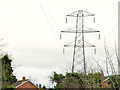
Pylon and power lines, Newtownbreda, Belfast
A pylon and power lines behind Berkley Court. They are a continuation, across the Belvoir Road Image, from Image
Image: © Albert Bridge
Taken: 31 Dec 2012
0.23 miles