IMAGES TAKEN NEAR TO
Galwally Avenue, BELFAST, BT8 7AJ
Introduction
This page details the photographs taken nearby to Galwally Avenue, BT8 7AJ by members of the Geograph project.
The Geograph project started in 2005 with the aim of publishing, organising and preserving representative images for every square kilometre of Great Britain, Ireland and the Isle of Man.

There are currently over 7.5m images from over14,400 individuals and you can help contribute to the project by visiting https://www.geograph.org.uk
Image Map
Images are licensed for reuse under creativecommons.org/licenses/by-sa/2.0
Notes
- Clicking on the map will re-center to the selected point.
- The higher the marker number, the further away the image location is from the centre of the postcode.
Image Listing (16 Images Found)
Images are licensed for reuse under creativecommons.org/licenses/by-sa/2.0
Image
Details
Distance
1
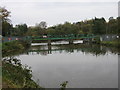
Weir on the Lagan at Stranmillis
Part of the works for the Lagan Navigation Canal.
Image: © Brian Shaw
Taken: 8 Nov 2005
0.12 miles
2
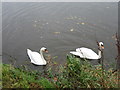
Swans on the Lagan
Just above the Weir at Stranmillis: unfortunately I had no food for them!
Image: © Brian Shaw
Taken: 8 Nov 2005
0.12 miles
3

Traffic waiting to join the A24 at the Galwally Road junction
Image: © Eric Jones
Taken: 7 Dec 2018
0.20 miles
4
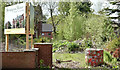
Mornington Manor, Annadale, Belfast - April 2017(1)
This long-term vacant site now has an agents’ board advertising a proposed development of apartments.
Image: © Albert Bridge
Taken: 27 Apr 2017
0.21 miles
5
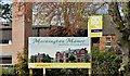
Mornington Manor, Annadale, Belfast - April 2017(2)
The agents’ board advertising a proposed development of apartments. This church Image is in the background.
Image: © Albert Bridge
Taken: 27 Apr 2017
0.21 miles
6
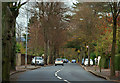
Annadale Avenue, Belfast
Annadale Avenue runs from the Ormeau Road to the Annadale Embankment. It seems to date from towards the end of the 19th century when this part of southeast Belfast began to be developed. In common with similar areas in the south and east some large detached houses have been demolished and replaced by apartments.
Image: © Albert Bridge
Taken: 9 Nov 2009
0.21 miles
7
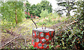
Vacant site, Annadale, Belfast
A vacant site on the southern side of Annadale Avenue. This church Image is just out of picture to the right
Image: © Albert Bridge
Taken: 7 Sep 2013
0.21 miles
8
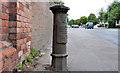
Boundary post, south Belfast (1)
See Image The same post, from a different angle, showing its position beside the main road. Image shows the plate with the division and ward names.
Image: © Albert Bridge
Taken: 20 Jul 2011
0.22 miles
9
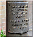
Boundary post, south Belfast (2)
The plate, showing the division and ward, on Image
Image: © Albert Bridge
Taken: 20 Jul 2011
0.22 miles
10
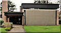
Mormon church, Belfast (2)
See Image This one is at Annadale Avenue Image, on the Ormeau Road side of Mornington. Image shows the church at Whiteabbey.
Image: © Albert Bridge
Taken: 8 Mar 2012
0.22 miles