IMAGES TAKEN NEAR TO
Newtownbreda Road, BELFAST, BT8 6PY

Introduction

This page details the photographs taken nearby to Newtownbreda Road, BT8 6PY by members of the Geograph project.

The Geograph project started in 2005 with the aim of publishing, organising and preserving representative images for every square kilometre of Great Britain, Ireland and the Isle of Man.

There are currently over 7.5m images from over14,400 individuals and you can help contribute to the project by visiting https://www.geograph.org.uk

Image Map


Images are licensed for reuse under creativecommons.org/licenses/by-sa/2.0
Notes
  • Clicking on the map will re-center to the selected point.
  • The higher the marker number, the further away the image location is from the centre of the postcode.

Image Listing (10 Images Found)

Images are licensed for reuse under creativecommons.org/licenses/by-sa/2.0
Image
Details
Distance
1
Belvoir Road, Belfast [1]
The Belvoir Road forms part of the 'Outer Ring' around the centre of Belfast. This is the view towards Newtownbreda.
Image: © Rossographer Taken: 25 Jan 2008
0.11 miles
2
The Belvoir Road, Belfast (1)
The first part of the Belfast outer ring road, between the Saintfield Road (now “Forestside” and originally “Supermac”) and Knock, to open - back in 1959. The view is towards Knock from this footbridge Image The street lights are not original.
Image: © Albert Bridge Taken: 31 Dec 2012
0.13 miles
3
Footbridge, Newtownbreda, Belfast
A footbridge, across the Belvoir Road, connecting the Newtownbreda Road (behind me) to the Belvoir estate and forest. The road opened in 1959.
Image: © Albert Bridge Taken: 31 Dec 2012
0.18 miles
4
Letter box, Newtownbreda, Belfast
Post-mounted EIIR letter box (BT8 872) at Beaufort Avenue, off the Beechill Road.
Image: © Albert Bridge Taken: 31 Dec 2012
0.21 miles
5
Former Newtownbreda Primary School, Belfast (1)
The former Newtownbreda Primary School, School Road off the Saintfield Road, built in 1938, in a style reminiscent of the much bigger Floral Hall (1936 – architect David W Boyd). Closed 2009 and now offered for sale. This was the main entrance. Image shows the “for sale” sign.
Image: © Albert Bridge Taken: 23 Jan 2012
0.21 miles
6
Beechill Road, Belfast
Looking up from the Newtownbreda Road.
Image: © Rossographer Taken: 25 Jan 2008
0.22 miles
7
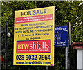
Former Newtownbreda Primary School, Belfast (2)
See Image The “for sale” board. The agent’s website describes the property as “. . . .the site has good development potential for residential units given its location in the popular suburbs of Belfast. Dwellings in the immediate vicinity are detached and semi detached ranging between 1.5 and 2 story in height. Planning Outline planning permission (Ref: Y/2010/0014/O) was granted on 2nd November 2010 comprising a mixture of detached and semi detached dwellings”. This photograph appears as a matter of record only. I have no connection with any of the parties involved in the sale.
Image: © Albert Bridge Taken: 23 Jan 2012
0.22 miles
8
Pillar box, Belfast
EIIR pillar box (BT8 803), on the Newtownbreda Road, opposite the end of the School Road.
Image: © Albert Bridge Taken: 23 Jan 2012
0.23 miles
9
Houses at Woodbreda Park
Image: © Eric Jones Taken: 15 Feb 2012
0.24 miles
10
Entrance to Woodbreda Park
Woodbreda is a modern housing estate in the outer suburbs of Belfast.
Image: © Eric Jones Taken: 15 Feb 2012
0.25 miles