IMAGES TAKEN NEAR TO
Rocky Road, BELFAST, BT8 6GA
Introduction
This page details the photographs taken nearby to Rocky Road, BT8 6GA by members of the Geograph project.
The Geograph project started in 2005 with the aim of publishing, organising and preserving representative images for every square kilometre of Great Britain, Ireland and the Isle of Man.

There are currently over 7.5m images from over14,400 individuals and you can help contribute to the project by visiting https://www.geograph.org.uk
Image Map
Images are licensed for reuse under creativecommons.org/licenses/by-sa/2.0
Notes
- Clicking on the map will re-center to the selected point.
- The higher the marker number, the further away the image location is from the centre of the postcode.
Image Listing (20 Images Found)
Images are licensed for reuse under creativecommons.org/licenses/by-sa/2.0
Image
Details
Distance
1
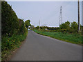
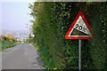
The Rocky Road, Belfast
Minor road running from the Manse Road to the Upper Knockbreda Road / outer ring road in east Belfast. This is the view from the Manse Road - at this point it looks like a pleasant and quiet country road but a little further along it suddenly descends with a 1 in 5 drop and several sharp bends - see Image Best to test the brakes first and avoid altogether in icy conditions (the road is prone to being closed if the weather is particularly severe).
Image: © Rossographer
Taken: 20 Apr 2011
0.01 miles
2
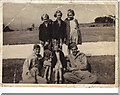
US Cemetery at Lisnabreeny
Picture taken of the US Cemetery at Lisnabreeny (Rocky Road). Belfast can be seen in the background.
L to R: Back: Kathleen and Mary Close, Evelyn Barnes. Front: Beth Smith, Ann Close with US soldiers Don Fluge and Melton Hale
The soldiers were looking after the site.
Image: © Jim Kane
Taken: Unknown
0.03 miles
3
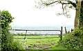
Field gate, Belfast
A field gate on the western side of the Rocky Road Image The view over south and west Belfast is hindered by the heavy rain (though the sun made an appearance in the afternoon).
Image: © Albert Bridge
Taken: 19 May 2014
0.05 miles
4

Fields and trees, Glencregagh, Belfast (June 2014)
Most of Cregagh Glen lies just outside the present limit of built-up east Belfast. The surrounding area is still agricultural – see Image and Image This view is from close to here Image
Image: © Albert Bridge
Taken: 25 Jun 2014
0.06 miles
5
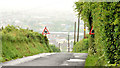
The Rocky Road, Belfast (May 2014)
See Image (April 2011). A similar view, on a very wet day, just over three years later.
Image: © Albert Bridge
Taken: 19 May 2014
0.06 miles
6
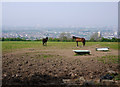
Horses near Belfast
A field and two horses off the Rocky Road above east Belfast. The city can be glimpsed through the haze, although on a clear day much more would be visible.
Image: © Rossographer
Taken: 20 Apr 2011
0.09 miles
7
The Rocky Road, Belfast
Minor road running from the Manse Road to the Upper Knockbreda Road / outer ring road in east Belfast. This is the view approaching Knockbreda when it suddenly descends with a 1 in 5 drop and several sharp bends. Best to test the brakes first and avoid altogether in icy conditions (the road is prone to being closed if the weather is particularly severe). See also Image Central Belfast can be glimpsed through the haze.
Image: © Rossographer
Taken: 20 Apr 2011
0.12 miles
8
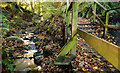
River and steps, Cregagh Glen, Belfast
The Cregagh River (left) descending as another set of steps Image ascends. Position approximate. See also Image
Image: © Albert Bridge
Taken: 1 Nov 2012
0.17 miles
9
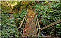
Footbridge, Cregagh Glen, Belfast (2)
See Image The view, down, to the footbridge across the Cregagh River.
Image: © Albert Bridge
Taken: 1 Nov 2012
0.17 miles
10
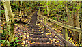
Steps, Cregagh Glen, Belfast
The glen is on a steep hillside close to here Image This is one of the many sets of steps used to help the path ascend the hill. Position approximate.
Image: © Albert Bridge
Taken: 1 Nov 2012
0.17 miles