IMAGES TAKEN NEAR TO
Castlegrange Park, STRABANE, BT82 9WB
Introduction
This page details the photographs taken nearby to Castlegrange Park, BT82 9WB by members of the Geograph project.
The Geograph project started in 2005 with the aim of publishing, organising and preserving representative images for every square kilometre of Great Britain, Ireland and the Isle of Man.

There are currently over 7.5m images from over14,400 individuals and you can help contribute to the project by visiting https://www.geograph.org.uk
Image Map
Images are licensed for reuse under creativecommons.org/licenses/by-sa/2.0
Notes
- Clicking on the map will re-center to the selected point.
- The higher the marker number, the further away the image location is from the centre of the postcode.
Image Listing (4 Images Found)
Images are licensed for reuse under creativecommons.org/licenses/by-sa/2.0
Image
Details
Distance
2
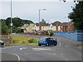
Castletown Townland
In the distance is the rear of Image] at Ballycolman
Image: © Kenneth Allen
Taken: 17 Feb 2015
0.24 miles
3
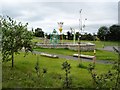
New school playground
An attractive playground at a new school at Melmont in Strabane.
Image: © Kay Atherton
Taken: 24 Aug 2007
0.25 miles
4
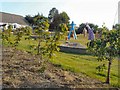
Figures in a playground
Tall figures in the evening light in a children's playground at Melmount in Strabane.
Image: © Kay Atherton
Taken: 8 Jun 2007
0.25 miles