IMAGES TAKEN NEAR TO
Somerville Road, STRABANE, BT82 9QZ
Introduction
This page details the photographs taken nearby to Somerville Road, BT82 9QZ by members of the Geograph project.
The Geograph project started in 2005 with the aim of publishing, organising and preserving representative images for every square kilometre of Great Britain, Ireland and the Isle of Man.

There are currently over 7.5m images from over14,400 individuals and you can help contribute to the project by visiting https://www.geograph.org.uk
Image Map
Images are licensed for reuse under creativecommons.org/licenses/by-sa/2.0
Notes
- Clicking on the map will re-center to the selected point.
- The higher the marker number, the further away the image location is from the centre of the postcode.
Image Listing (9 Images Found)
Images are licensed for reuse under creativecommons.org/licenses/by-sa/2.0
Image
Details
Distance
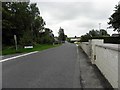
1

Hillhead Road, Somervillestown
Looking SSE from Bells Park Road
Image: © Kenneth Allen
Taken: 24 Sep 2010
0.14 miles
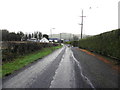
2
Bells Park Road, Somervillestown
Heading ESE
Image: © Kenneth Allen
Taken: 24 Sep 2010
0.14 miles
3
Hillhead Road, Kennystown
Heading north towards Bellspark Road
Image: © Kenneth Allen
Taken: 6 Jan 2015
0.17 miles
4
Bells Park Road, Somervillestown
Heading WNW towards Clady
Image: © Kenneth Allen
Taken: 24 Sep 2010
0.18 miles
5
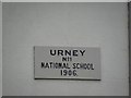
Plaque, Urney No1 National School
It is located here Image]
Image: © Kenneth Allen
Taken: 24 Sep 2010
0.19 miles
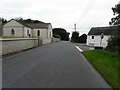
6
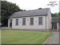
Urney No1 National School
Built in 1906; it is located beside the Presbyterian Church
See close-up of plaque here Image]
Image: © Kenneth Allen
Taken: 24 Jun 2006
0.19 miles
7
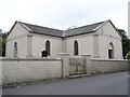
Urney Presbyterian Church
It is located at Kennystown, Clady
Image: © Kenneth Allen
Taken: 24 Jun 2006
0.19 miles
8
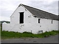
Old building at Somertown Road
They didn't think about handrails to stairs in the old days
Image: © Kenneth Allen
Taken: 24 Jun 2006
0.19 miles
9
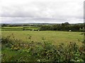
Kennystown Townland
Looking north-west from Somerville Road
Image: © Kenneth Allen
Taken: 24 Sep 2010
0.22 miles