IMAGES TAKEN NEAR TO
Urbalreagh Road, STRABANE, BT82 9JL
Introduction
This page details the photographs taken nearby to Urbalreagh Road, BT82 9JL by members of the Geograph project.
The Geograph project started in 2005 with the aim of publishing, organising and preserving representative images for every square kilometre of Great Britain, Ireland and the Isle of Man.

There are currently over 7.5m images from over14,400 individuals and you can help contribute to the project by visiting https://www.geograph.org.uk
Image Map
Images are licensed for reuse under creativecommons.org/licenses/by-sa/2.0
Notes
- Clicking on the map will re-center to the selected point.
- The higher the marker number, the further away the image location is from the centre of the postcode.
Image Listing (6 Images Found)
Images are licensed for reuse under creativecommons.org/licenses/by-sa/2.0
Image
Details
Distance
1
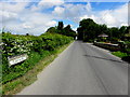
Urbalreagh Road, Clady Blair
Heading north
Image: © Kenneth Allen
Taken: 3 Jun 2014
0.03 miles
2
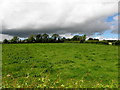
A dark sky at Clady Blair
Looking weswt from Urbalreagh Road
Image: © Kenneth Allen
Taken: 3 Jun 2014
0.10 miles
3
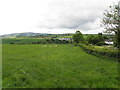
Clady Blair Townland
Pictured along Urbalreagh Road
Image: © Kenneth Allen
Taken: 3 Jun 2014
0.11 miles
4
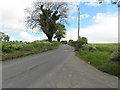
Urbalreagh Road
Heading north at Clady Blair
Image: © Kenneth Allen
Taken: 3 Jun 2014
0.13 miles
5
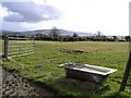
Clady Hill, Ardstraw
It seems like a funny place to take a bath, but numerous farmers use them as watering troughs for cattle
Image: © Kenneth Allen
Taken: 10 Mar 2006
0.16 miles
6
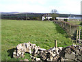
Urbalreagh Townland
The view is looking east.
Image: © Kenneth Allen
Taken: 10 Mar 2006
0.17 miles