IMAGES TAKEN NEAR TO
Mill Avenue, STRABANE, BT82 9HE
Introduction
This page details the photographs taken nearby to Mill Avenue, BT82 9HE by members of the Geograph project.
The Geograph project started in 2005 with the aim of publishing, organising and preserving representative images for every square kilometre of Great Britain, Ireland and the Isle of Man.

There are currently over 7.5m images from over14,400 individuals and you can help contribute to the project by visiting https://www.geograph.org.uk
Image Map
Images are licensed for reuse under creativecommons.org/licenses/by-sa/2.0
Notes
- Clicking on the map will re-center to the selected point.
- The higher the marker number, the further away the image location is from the centre of the postcode.
Image Listing (107 Images Found)
Images are licensed for reuse under creativecommons.org/licenses/by-sa/2.0
Image
Details
Distance
1
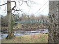
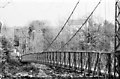
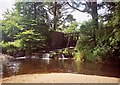
Bearney Footbridge, Sion Mills
Sion Mills' plentiful water resource-the River Mourne- which once sustained the village's flax industry now provides the centre piece for an idyllic riverside haven, incorporating excellent angling facilities and the Mourneside Walk.
This scenic riverside walk features the popular 'Bearney'footbridge known locally as the 'Swinging Bridge', picnic sites as well as an attractive weir across the river which the Salmon cross on their migration upstream to the Strule, Derg, Owenkillew, and Glenelly rivers.
Image: © Kenneth Allen
Taken: 7 Jun 2001
0.02 miles
2
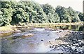
Looking downstream from the "Swingin' Bridge"
It's August and the water is in a dire state as far as the angler is concerned.
Image: © Des Colhoun
Taken: 10 Aug 1975
0.05 miles
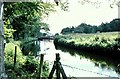
3
The Gravenue on the Mourne at Sion Mills
A premier salmon pool in bygone days when accomplished anglers with 16 foot greenheart rods would live on the Gravenue during the height of the salmon fishing season.
Image: © Des Colhoun
Taken: 14 Jul 2001
0.06 miles
4
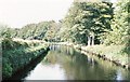
"The Lade" or mill race driving the turbines at Sion Mills
A once busy flax mill used the power provided by the River Mourne to drive the turbines vis this or Lade as it is locally known. In the distance you can see the sluice gates which control the rate of flow of the water.
Image: © Des Colhoun
Taken: 20 Jul 1985
0.06 miles
5
Downstream view from the Lade bridge
Another great swimming venue for the village youth, though sometimes with fatal consequences.
Image: © Des Colhoun
Taken: 10 Aug 1975
0.07 miles
6
"The rack" on the lade at Herdman's Mill
This is the mill race which drove the turbines which powered the linen mill here at Sion Mills.
Image: © Des Colhoun
Taken: 31 Dec 2009
0.07 miles
7
Looking upstream from the "Swingin' Bridge"
The River Mourne is a good salmon river and the pool in view with the "broken" water is known as Purgatory. In this case however it represents the final resting place for the salmon before they enter "The Gravenue" which can be seen in the distance.
Image: © Des Colhoun
Taken: 10 Aug 1975
0.07 miles
8
The Swingin' Bridge at Sion Mills
A playground for the village children of the 50's and 60's and also a means of getting to work if you lived on the "Far Side". That lane leading on to the bridge on the "far Side" was known as the Duck Walk.
Image: © Des Colhoun
Taken: 13 Jul 1985
0.08 miles
9
"The Hole" with the sluices in the background
Another popular swimming venue for the villagers in the summertime and a gift to the angler when the river was in spate.
Image: © Des Colhoun
Taken: 14 Jul 2001
0.09 miles
10
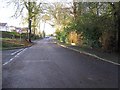
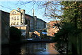
Mill Avenue, Sion Mills
The view the mill workers would have seen, when coming from work
Image: © Kenneth Allen
Taken: 10 Dec 2008
0.09 miles