IMAGES TAKEN NEAR TO
Summerhill Court, STRABANE, BT82 9FJ
Introduction
This page details the photographs taken nearby to Summerhill Court, BT82 9FJ by members of the Geograph project.
The Geograph project started in 2005 with the aim of publishing, organising and preserving representative images for every square kilometre of Great Britain, Ireland and the Isle of Man.

There are currently over 7.5m images from over14,400 individuals and you can help contribute to the project by visiting https://www.geograph.org.uk
Image Map
Images are licensed for reuse under creativecommons.org/licenses/by-sa/2.0
Notes
- Clicking on the map will re-center to the selected point.
- The higher the marker number, the further away the image location is from the centre of the postcode.
Image Listing (8 Images Found)
Images are licensed for reuse under creativecommons.org/licenses/by-sa/2.0
Image
Details
Distance
1
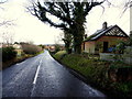
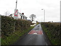
Urney Road, Carricklee
Heading north-east towards Strabane
Image: © Kenneth Allen
Taken: 17 Feb 2015
0.15 miles
2
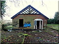
Ruined gatehouse, Carricklee
Pictured along Urney Road
Image: © Kenneth Allen
Taken: 17 Feb 2015
0.15 miles
3
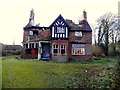
Derelict dwelling, Carricklee
It is located along Urney Road
Image: © Kenneth Allen
Taken: 17 Feb 2015
0.16 miles
4
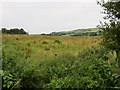
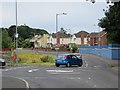
Field on the edge of Strabane
A field in the unenviable (unless you own it) position of being on the edge of town. Looking north into the South.
Image: © Richard Webb
Taken: 31 Jul 2013
0.20 miles
5
Castletown Road, Castletown
Heading north
Image: © Kenneth Allen
Taken: 17 Feb 2015
0.20 miles
7
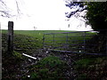
An open field, Carricklee
Pictured along Urney Road
Image: © Kenneth Allen
Taken: 17 Feb 2015
0.21 miles
8
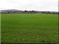
Castletown Townland
In the distance is the rear of Image] at Ballycolman
Image: © Kenneth Allen
Taken: 17 Feb 2015
0.23 miles