IMAGES TAKEN NEAR TO
O'Kane Terrace, STRABANE, BT82 9EY
Introduction
This page details the photographs taken nearby to O'Kane Terrace, BT82 9EY by members of the Geograph project.
The Geograph project started in 2005 with the aim of publishing, organising and preserving representative images for every square kilometre of Great Britain, Ireland and the Isle of Man.

There are currently over 7.5m images from over14,400 individuals and you can help contribute to the project by visiting https://www.geograph.org.uk
Image Map
Images are licensed for reuse under creativecommons.org/licenses/by-sa/2.0
Notes
- Clicking on the map will re-center to the selected point.
- The higher the marker number, the further away the image location is from the centre of the postcode.
Image Listing (8 Images Found)
Images are licensed for reuse under creativecommons.org/licenses/by-sa/2.0
Image
Details
Distance
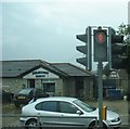
1
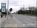
Melmount Road, Strabane
The A5 goes south to Omagh
Image: © Kenneth Allen
Taken: 21 Mar 2006
0.12 miles
2
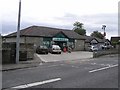
Mace, Strabane
It is located on the Melmount Road
Image: © Kenneth Allen
Taken: 23 Jul 2009
0.15 miles
3

St Mary's RC Church, Melmount Road, Strabane
It is located on the A5, to the south side of Strabane
Image: © Kenneth Allen
Taken: 21 Mar 2006
0.16 miles
4
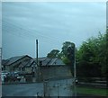
The Melmount Chippy, Melmount Road, Strabane
Image: © Eric Jones
Taken: 19 Aug 2009
0.18 miles
5
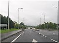
The Great Northern Link at the turn-off for the Orchard Industrial Estate
Image: © Eric Jones
Taken: 23 Jul 2012
0.18 miles
6

Fir Trees Hotel, Strabane
When I pictured this hotel I wondered if I was in the right location; it looked entirely different from the last time I was here
Image: © Kenneth Allen
Taken: 4 Oct 2008
0.18 miles
7
Entrance to Ballycolman Road from Melmount Road, Strabane
Image: © Eric Jones
Taken: 19 Aug 2009
0.19 miles
8
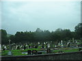
Melmount Cemetery, Strabane
This large cemetery lies on the east side of Melmount Road.
Image: © Eric Jones
Taken: 19 Aug 2009
0.22 miles