IMAGES TAKEN NEAR TO
Meendamph Road, STRABANE, BT82 0RR
Introduction
This page details the photographs taken nearby to Meendamph Road, BT82 0RR by members of the Geograph project.
The Geograph project started in 2005 with the aim of publishing, organising and preserving representative images for every square kilometre of Great Britain, Ireland and the Isle of Man.

There are currently over 7.5m images from over14,400 individuals and you can help contribute to the project by visiting https://www.geograph.org.uk
Image Map
Images are licensed for reuse under creativecommons.org/licenses/by-sa/2.0
Notes
- Clicking on the map will re-center to the selected point.
- The higher the marker number, the further away the image location is from the centre of the postcode.
Image Listing (7 Images Found)
Images are licensed for reuse under creativecommons.org/licenses/by-sa/2.0
Image
Details
Distance
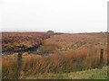
2
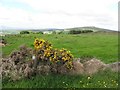
Meendamph Townland
Some whins dead and alive - they're taking some time to rejuvenate after the severe cold weather in previous years
Image: © Kenneth Allen
Taken: 19 Jun 2013
0.19 miles
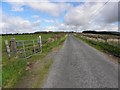
3
Meendamph Road
Heading NNW at Meendamph
Image: © Kenneth Allen
Taken: 19 Jun 2013
0.21 miles
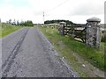
4
Meendamph Road, Meendamph
Heading NNW
Image: © Kenneth Allen
Taken: 19 Jun 2013
0.21 miles
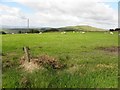
6
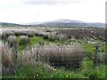
Rushy ground, Balix Upper
Looking ENE from Meendamph Road
Image: © Kenneth Allen
Taken: 19 Jun 2013
0.24 miles
7
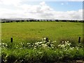
Balix Upper Townland
Looking SSE from Glencoppogagh Road
Image: © Kenneth Allen
Taken: 19 Jun 2013
0.25 miles